
大阪狹山市 topographic map
Interactive map
Click on the map to display elevation.
About this map
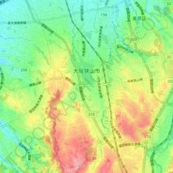
Name: 大阪狹山市 topographic map, elevation, terrain.
Location: 大阪狹山市, 大阪府, 日本 (34.46650 135.53264 34.52942 135.56677)
Average elevation: 92 m
Minimum elevation: 43 m
Maximum elevation: 164 m
本地在令制國時代屬於河內國丹比郡,過去被稱為狹山鄉,「狹山」之名源於本地位於羽曳野丘陵和河泉丘陵之間狹窄的地形。
Other topographic maps
Click on a map to view its topography, its elevation and its terrain.