
堺市 topographic map
Interactive map
Click on the map to display elevation.
About this map
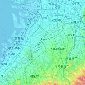
Name: 堺市 topographic map, elevation, terrain.
Location: 堺市, 大阪府, 540-8570, 日本 (34.43015 135.31163 34.61105 135.58764)
Average elevation: 60 m
Minimum elevation: -7 m
Maximum elevation: 666 m
堺市轄區西部為平原,沿著海岸線自古即有多條道路及鐵路通過,包括紀州街道(日语:紀州街道)、熊野街道、南海本線等多條重要路線,也因此是較早形成市區的地方;沿海區域則為堺泉北臨海工業地帶(日语:堺泉北臨海工業地帯)。中部及東部為丘陵地形,現主要為住宅區。
Other topographic maps
Click on a map to view its topography, its elevation and its terrain.