
阿波市 topographic map
Interactive map
Click on the map to display elevation.
About this map
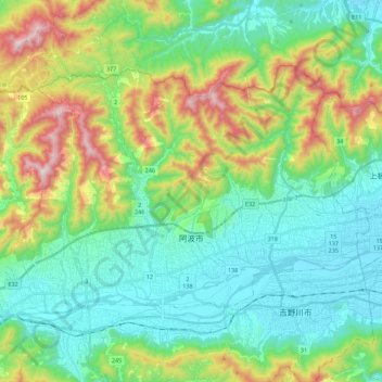
Name: 阿波市 topographic map, elevation, terrain.
Location: 阿波市, 德岛县, 日本 (34.06355 134.17879 34.18551 134.40162)
Average elevation: 220 m
Minimum elevation: 2 m
Maximum elevation: 772 m
Other topographic maps
Click on a map to view its topography, its elevation and its terrain.
白石川堤一目千本桜 桜のトンネル
白石川堤一目千本桜 桜のトンネル, 柴田バイパス, 槻木白幡五丁目, 槻木白幡, 柴田町, 柴田郡, 宫城县, 989-1622, 日本
Average elevation: 19 m