
香美市 topographic map
Interactive map
Click on the map to display elevation.
About this map
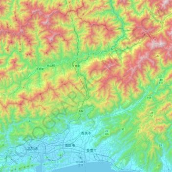
Name: 香美市 topographic map, elevation, terrain.
Location: 香美市, 高知县, 782-0009, 日本 (33.57968 133.59669 33.84086 134.06843)
Average elevation: 523 m
Minimum elevation: -3 m
Maximum elevation: 1,597 m
Other topographic maps
Click on a map to view its topography, its elevation and its terrain.
白石川堤一目千本桜 桜のトンネル
白石川堤一目千本桜 桜のトンネル, 柴田バイパス, 槻木白幡五丁目, 槻木白幡, 柴田町, 柴田郡, 宫城县, 989-1622, 日本
Average elevation: 19 m