
花卷市 topographic map
Interactive map
Click on the map to display elevation.
About this map
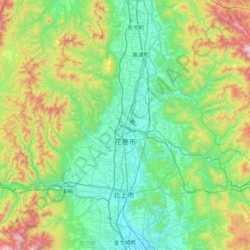
Name: 花卷市 topographic map, elevation, terrain.
Location: 花卷市, 岩手县, 025-0066, 日本 (39.26038 140.87868 39.57706 141.49578)
Average elevation: 358 m
Minimum elevation: 36 m
Maximum elevation: 1,407 m
Other topographic maps
Click on a map to view its topography, its elevation and its terrain.
白石川堤一目千本桜 桜のトンネル
白石川堤一目千本桜 桜のトンネル, 柴田バイパス, 槻木白幡五丁目, 槻木白幡, 柴田町, 柴田郡, 宫城县, 989-1622, 日本
Average elevation: 19 m