
赤磐市 topographic map
Interactive map
Click on the map to display elevation.
About this map
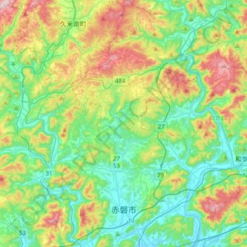
Name: 赤磐市 topographic map, elevation, terrain.
Location: 赤磐市, 冈山县, 日本 (34.71964 133.95629 34.95087 134.15221)
Average elevation: 171 m
Minimum elevation: 4 m
Maximum elevation: 554 m
Other topographic maps
Click on a map to view its topography, its elevation and its terrain.
白石川堤一目千本桜 桜のトンネル
白石川堤一目千本桜 桜のトンネル, 柴田バイパス, 槻木白幡五丁目, 槻木白幡, 柴田町, 柴田郡, 宫城县, 989-1622, 日本
Average elevation: 19 m