
肝属郡 topographic map
Interactive map
Click on the map to display elevation.
About this map
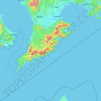
Name: 肝属郡 topographic map, elevation, terrain.
Location: 肝属郡, 鹿儿岛县, 日本 (30.84581 130.44712 31.43785 131.26686)
Average elevation: 53 m
Minimum elevation: -1 m
Maximum elevation: 1,205 m
Other topographic maps
Click on a map to view its topography, its elevation and its terrain.
白石川堤一目千本桜 桜のトンネル
白石川堤一目千本桜 桜のトンネル, 柴田バイパス, 槻木白幡五丁目, 槻木白幡, 柴田町, 柴田郡, 宫城县, 989-1622, 日本
Average elevation: 19 m