
南岗区 topographic map
Interactive map
Click on the map to display elevation.
About this map
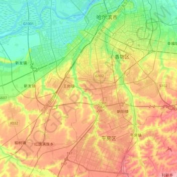
Name: 南岗区 topographic map, elevation, terrain.
Location: 南岗区, 哈尔滨市, 黑龙江省, 150000, 中国 (45.54274 126.43256 45.78159 126.71575)
Average elevation: 158 m
Minimum elevation: 113 m
Maximum elevation: 215 m
Other topographic maps
Click on a map to view its topography, its elevation and its terrain.