
幸福镇 topographic map
Interactive map
Click on the map to display elevation.
About this map
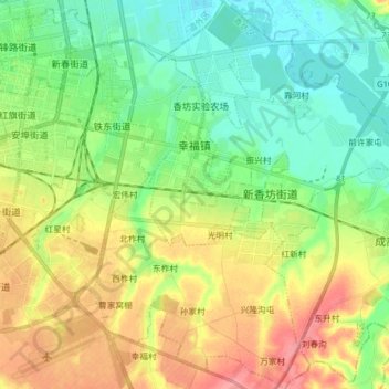
Name: 幸福镇 topographic map, elevation, terrain.
Location: 幸福镇, 香坊区, 哈尔滨市, 黑龙江省, 150000, 中国 (45.65464 126.69717 45.76447 126.85175)
Average elevation: 150 m
Minimum elevation: 120 m
Maximum elevation: 198 m
Other topographic maps
Click on a map to view its topography, its elevation and its terrain.