
South Africa topographic map
Interactive map
Click on the map to display elevation.
About this map
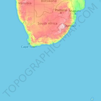
Name: South Africa topographic map, elevation, terrain.
Location: South Africa (-47.17883 16.33352 -22.12503 38.28990)
Average elevation: 221 m
Minimum elevation: 0 m
Maximum elevation: 3,367 m
South Africa is in southernmost Africa, with a coastline that stretches more than 2,500 km (1,553 mi) and along two oceans (the South Atlantic and the Indian). At 1,219,912 km2 (471,011 sq mi), South Africa is the 24th-largest country in the world. Excluding the Prince Edward Islands, the country lies between latitudes 22° and 35°S, and longitudes 16° and 33°E. The interior of South Africa consists of a large, in most places almost flat plateau with an altitude of between 1,000 m (3,300 ft) and 2,100 m (6,900 ft), highest in the east and sloping gently downwards towards the west and north, and slightly so to the south and south-west. This plateau is surrounded by the Great Escarpment whose eastern, and highest, stretch is known as the Drakensberg. Mafadi in the Drakensberg at 3,450 m (11,320 ft) is the highest peak. The KwaZulu-Natal–Lesotho international border is formed by the highest portion of the Great Escarpment which reaches an altitude of over 3,000 m (9,800 ft).
Other topographic maps
Click on a map to view its topography, its elevation and its terrain.
Ireland
Ireland
Average elevation: 44 m
Chasiv Yar
Chasiv Yar, Chasiv Yar urban hromada, Bakhmut Raion, Donetsk Oblast, 84551-84556, Ukraine
Average elevation: 213 m
Czechia
Czechia
Average elevation: 369 m
Croatia
Croatia
Average elevation: 323 m
Bangladesh
Bangladesh
Average elevation: 161 m
Latvia
Latvia
Average elevation: 72 m
Monterey County
Monterey County, California, United States
Average elevation: 282 m
Europe
Europe
Average elevation: 223 m
Madagascar
Madagascar
Average elevation: 139 m
Cork
Ireland > County Cork > Cork
Cork, County Cork, Munster, T12 T997, Ireland
Average elevation: 94 m
Carranstown
Carranstown, Duleek ED, The Municipal District of Laytown — Bettystown, County Meath, Leinster, Ireland
Average elevation: 36 m
Taiwan
Taiwan > Taiwan Province > Xinyi Township
Taiwan, Xinyi Township, Nantou County, Taiwan Province, Taiwan
Average elevation: 196 m
Catahoula Parish
Catahoula Parish, Louisiana, United States
Average elevation: 24 m
Galway City
Galway, Galway City, County Galway, Connacht, H91 YD86, Ireland
Average elevation: 26 m
Valencia
Spain > Valencian Community > Comarca de València
Valencia, Comarca de València, Valencia, Valencian Community, Spain
Average elevation: 37 m
Mother Nature's Crack
United States > Missouri > Newton County > Joplin > Cliff Village
Mother Nature's Crack, Cliff Village, Joplin, Newton County, Missouri, 64804, United States
Average elevation: 296 m
Primm
United States > Nevada > Clark County
Primm, Clark County, Nevada, United States
Average elevation: 817 m
Rattlesnake Lake
United States > Washington > Adams County
Rattlesnake Lake, Adams County, Washington, United States
Average elevation: 468 m
Cedar Falls
United States > Washington > Okanogan County
Cedar Falls, Okanogan County, Washington, United States
Average elevation: 1,375 m
Pachalik de Benguerir باشوية ابن جرير
Pachalik de Benguerir باشوية ابن جرير, Rhamna Province, Marrakech-Safi, Morocco
Average elevation: 473 m
Victorville
United States > California > San Bernardino County
Victorville, San Bernardino County, California, United States
Average elevation: 920 m
Cerro Gordo County
Cerro Gordo County, Iowa, United States
Average elevation: 358 m
Rathcormack
Rathcormack, Drumcliff South, Drumcliff West ED, Sligo Municipal Borough District, County Sligo, Connacht, F91 PY24, Ireland
Average elevation: 27 m
San Bernardino County
San Bernardino County, California, United States
Average elevation: 763 m
Thoiry
France > Auvergne-Rhône-Alpes > Ain
Thoiry, Gex, Ain, Auvergne-Rhône-Alpes, Metropolitan France, 01710, France
Average elevation: 713 m
Miłomłyn
Poland > Warmian-Masurian Voivodeship > Ostróda County
Miłomłyn, gmina Miłomłyn, Ostróda County, Warmian-Masurian Voivodeship, 14-140, Poland
Average elevation: 109 m
Aghamore
Aghamore, Claremorris-Swinford Municipal District, County Mayo, Connacht, Ireland
Average elevation: 111 m
Cornwall
United Kingdom > England > Fairy Cross
Cornwall, Broadoak, Fairy Cross, Cornwall, South West England, England, United Kingdom
Average elevation: 49 m
Tooele County
United States of America > Utah
Tooele County, Utah, United States of America
Average elevation: 1,462 m
Middlefield
United States > Ohio > Geauga County
Middlefield, Middlefield Township, Geauga County, Ohio, 44062, United States
Average elevation: 351 m