Geolocate

Garraf topographic map

Click on the map to display elevation.

About this map

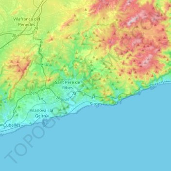
Name: Garraf topographic map, elevation, terrain.

Location: Garraf, Barcelona, Catalonia, Spain (41.19271 1.64092 41.32922 1.94455)

Average elevation: 148 m

Minimum elevation: -2 m

Maximum elevation: 648 m

Other topographic maps

Click on a map to view its topography, its elevation and its terrain.

Montjuïc

Spain > Catalonia > Barcelonès > Barcelona

Average elevation: 39 m

Sant Joan de Toran

Spain > Catalonia > Val d'Aran > Canejan

Average elevation: 1,496 m

Salou

Spain > Catalonia > Tarragonès > Salou > Salou

Average elevation: 15 m

Gear up for your next adventure:

🧥Waterproof Hiking Jackets - Rain jackets for unpredictable weather
🌍Travel Adapters - Adapters for international travel
🚰Hydration Packs - Hands‑free water storage for hikers
Solar Multisport Watches - Advanced mapping and GPS tracking for endurance hikers
🛡️Protective Bike Gear - Helmets & pads for safe rides

As an Amazon Associate, this site earns from qualifying purchases at no extra cost to you.