Geolocate

Salou topographic map

Click on the map to display elevation.

About this map

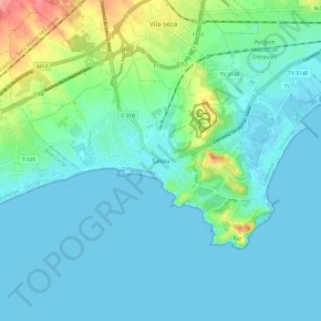
Name: Salou topographic map, elevation, terrain.

Location: Salou, Tarragonès, Tarragona, Catalonia, 43840, Spain (41.03682 1.10404 41.11682 1.18404)

Average elevation: 15 m

Minimum elevation: -4 m

Maximum elevation: 79 m

Gear up for your next adventure:

🧺Quick-Dry Hiking Towels - Space-saving towels for wild swimming or camping
🧴Anti-Chafe Sticks - Prevent friction during long distance walking
📸Travel Camera Tripods - Steady shots for landscape and long-exposure photos
🔋Portable Power Banks - Keep devices charged on long trips
🍖Freeze-Dried Trail Meals - Nutritious and lightweight food for expeditions

As an Amazon Associate, this site earns from qualifying purchases at no extra cost to you.