
Make a donation
Gear up for your next adventure:
As an Amazon Associate, this site earns from qualifying purchases at no extra cost to you.
Bangladesh topographic map
Click on the map to display elevation.
Make a donation
Gear up for your next adventure:
As an Amazon Associate, this site earns from qualifying purchases at no extra cost to you.
Bangladesh
Bangladesh is predominantly rich fertile flat land. Most of it is less than 12 m (39 ft) above sea level, and it is estimated that about 10% of its land would be flooded if the sea level were to rise by 1 m (3.3 ft). 17% of the country is covered by forests and 12% is covered by hill systems. The country's haor wetlands are of significance to global environmental science. The highest point in Bangladesh is the Saka Haphong, located near the border with Myanmar, with an elevation of 1,064 m (3,491 ft). Previously, either Keokradong or Tazing Dong were considered the highest.
Make a donation
Gear up for your next adventure:
As an Amazon Associate, this site earns from qualifying purchases at no extra cost to you.
About this map
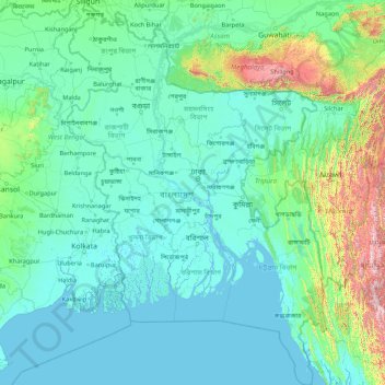
Name: Bangladesh topographic map, elevation, terrain.
Location: Bangladesh (20.36791 88.00792 26.63589 92.68020)
Average elevation: 161 m
Minimum elevation: -2 m
Maximum elevation: 2,636 m
Make a donation
Gear up for your next adventure:
As an Amazon Associate, this site earns from qualifying purchases at no extra cost to you.
Other topographic maps
Click on a map to view its topography, its elevation and its terrain.
Tbilisi
Most of the raions are named after historic quarters of the city. The citizens of Tbilisi widely recognise an informal system of smaller historic neighbourhoods. Such neighbourhoods are several, however, constituting a kind of hierarchy, because most of them have lost their distinctive topographic limits. The…
Average elevation: 713 m
Make a donation
Gear up for your next adventure:
As an Amazon Associate, this site earns from qualifying purchases at no extra cost to you.
Bandung
Indonesia > West Java > Bandung
Bandung, the capital of West Java province, located about 180 kilometres (110 mi) southeast of Jakarta, is the third-largest city in Indonesia. Its elevation is 768 metres (2,520 ft) above sea level and is surrounded by up to 2,400 metres (7,900 feet) high Late Tertiary and Quaternary volcanic terrain. The 400…
Average elevation: 879 m
Make a donation
Gear up for your next adventure:
As an Amazon Associate, this site earns from qualifying purchases at no extra cost to you.
Europe
Europe's topography is characterized by a striking contrast between its rugged southern mountains and the expansive plains of the north. The continent is often described as a "peninsula of peninsulas," featuring major peninsulas like the Iberian, Italian, and Balkan, each with unique geological features. In…
Average elevation: 223 m
Make a donation
Gear up for your next adventure:
As an Amazon Associate, this site earns from qualifying purchases at no extra cost to you.
Make a donation
Gear up for your next adventure:
As an Amazon Associate, this site earns from qualifying purchases at no extra cost to you.
Make a donation
Gear up for your next adventure:
As an Amazon Associate, this site earns from qualifying purchases at no extra cost to you.
Make a donation
Gear up for your next adventure:
As an Amazon Associate, this site earns from qualifying purchases at no extra cost to you.
Make a donation
Gear up for your next adventure:
As an Amazon Associate, this site earns from qualifying purchases at no extra cost to you.
Make a donation
Gear up for your next adventure:
As an Amazon Associate, this site earns from qualifying purchases at no extra cost to you.
Make a donation
Gear up for your next adventure:
As an Amazon Associate, this site earns from qualifying purchases at no extra cost to you.
Make a donation
Gear up for your next adventure:
As an Amazon Associate, this site earns from qualifying purchases at no extra cost to you.
Battle of the Seelow Heights
Germany > Brandenburg > Märkisch-Oderland > Seelow
Average elevation: 22 m
Make a donation
Gear up for your next adventure:
As an Amazon Associate, this site earns from qualifying purchases at no extra cost to you.
Nkowankowa
South Africa > Limpopo > Mopani District Municipality > Greater Tzaneen Local Municipality
Average elevation: 544 m
Make a donation
Gear up for your next adventure:
As an Amazon Associate, this site earns from qualifying purchases at no extra cost to you.
Make a donation
Gear up for your next adventure:
As an Amazon Associate, this site earns from qualifying purchases at no extra cost to you.
Make a donation
Gear up for your next adventure:
As an Amazon Associate, this site earns from qualifying purchases at no extra cost to you.
Make a donation
Gear up for your next adventure:
As an Amazon Associate, this site earns from qualifying purchases at no extra cost to you.
Make a donation
Gear up for your next adventure:
As an Amazon Associate, this site earns from qualifying purchases at no extra cost to you.
Make a donation
Gear up for your next adventure:
As an Amazon Associate, this site earns from qualifying purchases at no extra cost to you.
Great Skellig
The island is of special interest to archaeologists, as the monastic settlement is in unusually good condition. The monastery on the northern peak is situated at an elevation of 170 to 180 m (550 to 600 ft), Christ's Saddle at 129 m (422 ft), and the flagstaff area are 37 m (120 ft) above sea level. The…
Average elevation: 1 m
Lambay Island
Lambay Island is the largest island off the east coast of Ireland. It covers about 2.5 km2 (0.97 sq mi). The highest point – a hill known as Knockbane – rises to 126 m (413 ft). The island's high ground lies to the east and aside from Knockbane includes Heath Hill and Tinian Hill, and in the extreme…
Average elevation: 14 m
Make a donation
Gear up for your next adventure:
As an Amazon Associate, this site earns from qualifying purchases at no extra cost to you.
Make a donation
Gear up for your next adventure:
As an Amazon Associate, this site earns from qualifying purchases at no extra cost to you.
Make a donation
Gear up for your next adventure:
As an Amazon Associate, this site earns from qualifying purchases at no extra cost to you.
Make a donation
Gear up for your next adventure:
As an Amazon Associate, this site earns from qualifying purchases at no extra cost to you.
Make a donation
Gear up for your next adventure:
As an Amazon Associate, this site earns from qualifying purchases at no extra cost to you.
Make a donation
Gear up for your next adventure:
As an Amazon Associate, this site earns from qualifying purchases at no extra cost to you.
Lugnaquilla
Lugnaquilla is the 432nd-highest and 21st most prominent mountain in Britain and Ireland, on the Simms classification. It is regarded by the Scottish Mountaineering Club (SMC) as one of 34 Furths, which is a mountain above 3,000 ft (914 m) in elevation, and meets the other SMC criteria for a Munro (e.g.…
Average elevation: 696 m
Knocknapeasta
It is the 231st-highest mountain in Britain and Ireland on the Simm classification. Cnoc na Péiste is regarded by the Scottish Mountaineering Club ("SMC") as one of 34 Furths, which is a mountain above 3,000 ft (914.4 m) in elevation, and meets the other SMC criteria for a Munro (e.g. "sufficient…
Average elevation: 579 m
Caher
Caher is the 200th–highest mountain in Britain and Ireland on the Simm classification. Caher is regarded by the Scottish Mountaineering Club ("SMC") as one of 34 Furths, which is a mountain above 3,000 ft (914.4 m) in elevation, and meets the other SMC criteria for a Munro (e.g. "sufficient separation"), but…
Average elevation: 617 m
Beenkeragh
Beenkeragh is the second-highest peak in Ireland, on both the Arderin and Vandeleur-Lynam lists. It is the 179th-highest mountain in Britain and Ireland on the Simm classification. Beenkeragh is regarded by the Scottish Mountaineering Club ("SMC") as one of 34 Furths, which is a mountain above 3,000 ft (914 m)…
Average elevation: 654 m
Make a donation
Gear up for your next adventure:
As an Amazon Associate, this site earns from qualifying purchases at no extra cost to you.
Make a donation
Gear up for your next adventure:
As an Amazon Associate, this site earns from qualifying purchases at no extra cost to you.