
Make a donation
Gear up for your next adventure:
As an Amazon Associate, this site earns from qualifying purchases at no extra cost to you.
New Westminster topographic map
Click on the map to display elevation.
Make a donation
Gear up for your next adventure:
As an Amazon Associate, this site earns from qualifying purchases at no extra cost to you.
About this map
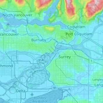
Name: New Westminster topographic map, elevation, terrain.
Average elevation: 87 m
Minimum elevation: -4 m
Maximum elevation: 1,192 m
Make a donation
Gear up for your next adventure:
As an Amazon Associate, this site earns from qualifying purchases at no extra cost to you.
Other topographic maps
Click on a map to view its topography, its elevation and its terrain.
Vancouver
Canada > British Columbia > Metro Vancouver Regional District
Vancouver, British Columbia, is situated on the Burrard Peninsula, bordered by Burrard Inlet to the north and the Fraser River to the south. The city's topography is a blend of flat and hilly terrains, with elevations ranging from sea level to approximately 152 meters (500 feet) above sea level. The North…
Average elevation: 34 m
Burnaby
Canada > British Columbia > Metro Vancouver Regional District
Burnaby occupies 98.6 square kilometres (38.1 sq mi) and is located at the geographic centre of the Metro Vancouver Regional District. The regional district's government is located in Burnaby's Metrotown area. Situated between the city of Vancouver on the west and Port Moody, Coquitlam, and New Westminster on…
Average elevation: 59 m
Tsawwassen
Canada > British Columbia > Metro Vancouver Regional District > Delta
Average elevation: 12 m
Make a donation
Gear up for your next adventure:
As an Amazon Associate, this site earns from qualifying purchases at no extra cost to you.
Township of Langley
Canada > British Columbia > Metro Vancouver Regional District
Average elevation: 47 m
Coquitlam
Canada > British Columbia > Metro Vancouver Regional District
Like much of Metro Vancouver, Coquitlam has an oceanic climate (Köppen climate type Cfb), experiencing mild temperatures and high precipitation; warm, dry summers and cool, wet winters. However, compared to most other cities in the area, precipitation is especially heavy in Coquitlam due to its proximity to…
Average elevation: 190 m
Make a donation
Gear up for your next adventure:
As an Amazon Associate, this site earns from qualifying purchases at no extra cost to you.
West End
Canada > British Columbia > Metro Vancouver Regional District > Vancouver
Average elevation: 15 m
Make a donation
Gear up for your next adventure:
As an Amazon Associate, this site earns from qualifying purchases at no extra cost to you.
Riley Park
Canada > British Columbia > Metro Vancouver Regional District > Vancouver
Average elevation: 75 m
Stanley Park
Canada > British Columbia > Metro Vancouver Regional District > Vancouver
Average elevation: 14 m
Golden Ears Provincial Park
Canada > British Columbia > Metro Vancouver Regional District
Average elevation: 794 m
Make a donation
Gear up for your next adventure:
As an Amazon Associate, this site earns from qualifying purchases at no extra cost to you.
University Endowment Lands
Canada > British Columbia > Metro Vancouver Regional District
Snowfalls are also more common than many parts of the City of Vancouver because of the area's higher altitude and the lack of an urban heat island due to less terrestrial development.
Average elevation: 58 m
Aldergrove
Canada > British Columbia > Metro Vancouver Regional District > Township of Langley
Average elevation: 107 m
Kitsilano 6
Canada > British Columbia > Metro Vancouver Regional District > Vancouver
Average elevation: 22 m
Fraser River (North Arm)
Canada > British Columbia > Metro Vancouver Regional District > Richmond
Average elevation: 27 m
Make a donation
Gear up for your next adventure:
As an Amazon Associate, this site earns from qualifying purchases at no extra cost to you.
Lower Seymour Conservation Reserve
Canada > British Columbia > Metro Vancouver Regional District > Electoral Area A
Average elevation: 605 m
Pitt Lake
Canada > British Columbia > Metro Vancouver Regional District > Electoral Area A
Average elevation: 659 m
Make a donation
Gear up for your next adventure:
As an Amazon Associate, this site earns from qualifying purchases at no extra cost to you.
Buntzen Bay
Canada > British Columbia > Metro Vancouver Regional District > Anmore
Average elevation: 214 m
Whonnock Lake
Canada > British Columbia > Metro Vancouver Regional District > Maple Ridge
Average elevation: 190 m
Cloverdale
Canada > British Columbia > Metro Vancouver Regional District > Surrey
Average elevation: 24 m
Make a donation
Gear up for your next adventure:
As an Amazon Associate, this site earns from qualifying purchases at no extra cost to you.
Woodlot 0007
Canada > British Columbia > Metro Vancouver Regional District > Maple Ridge
Average elevation: 322 m
Walnut Park
Canada > British Columbia > Metro Vancouver Regional District > Surrey
Average elevation: 49 m
Make a donation
Gear up for your next adventure:
As an Amazon Associate, this site earns from qualifying purchases at no extra cost to you.
Annacis Island
Canada > British Columbia > Metro Vancouver Regional District > Delta
Average elevation: 16 m
Serpentine Heights Park
Canada > British Columbia > Metro Vancouver Regional District > Surrey
Average elevation: 59 m
Make a donation
Gear up for your next adventure:
As an Amazon Associate, this site earns from qualifying purchases at no extra cost to you.
Vancouver
Canada > British Columbia > Metro Vancouver Regional District
Vancouver, British Columbia, is situated on the Burrard Peninsula, bordered by Burrard Inlet to the north and the Fraser River to the south. The city's topography is a blend of flat and hilly terrains, with elevations ranging from sea level to approximately 152 meters (500 feet) above sea level. The North…
Average elevation: 34 m
Bowen Island
Canada > British Columbia > Metro Vancouver Regional District > Bowen Island Municipality
Average elevation: 106 m
Town Centre Park
Canada > British Columbia > Metro Vancouver Regional District > Coquitlam
Average elevation: 62 m
Make a donation
Gear up for your next adventure:
As an Amazon Associate, this site earns from qualifying purchases at no extra cost to you.
Finn Slough
Canada > British Columbia > Metro Vancouver Regional District > Richmond
Average elevation: 2 m
Alouette Lake
Canada > British Columbia > Metro Vancouver Regional District > Maple Ridge
Average elevation: 549 m
Victoria-Fraserview
Canada > British Columbia > Metro Vancouver Regional District > Vancouver
Average elevation: 67 m
English Bay
Canada > British Columbia > Metro Vancouver Regional District > Vancouver
Average elevation: 7 m
Make a donation
Gear up for your next adventure:
As an Amazon Associate, this site earns from qualifying purchases at no extra cost to you.
Steveston
Canada > British Columbia > Metro Vancouver Regional District > Richmond
Average elevation: 2 m
Blue Mountain Park
Canada > British Columbia > Metro Vancouver Regional District > Coquitlam
Average elevation: 119 m
Livingstone Lake
Canada > British Columbia > Metro Vancouver Regional District > Vancouver
Average elevation: 86 m
Make a donation
Gear up for your next adventure:
As an Amazon Associate, this site earns from qualifying purchases at no extra cost to you.
Surrey Lake
Canada > British Columbia > Metro Vancouver Regional District > Surrey
Average elevation: 26 m
Tsawwassen Causeway Beach
Canada > British Columbia > Metro Vancouver Regional District > Delta
Average elevation: 1 m
Yew Lake
Canada > British Columbia > Metro Vancouver Regional District > West Vancouver
Average elevation: 990 m
Jericho Beach
Canada > British Columbia > Metro Vancouver Regional District > Vancouver
Average elevation: 20 m
Make a donation
Gear up for your next adventure:
As an Amazon Associate, this site earns from qualifying purchases at no extra cost to you.
Deer Lake Park
Canada > British Columbia > Metro Vancouver Regional District > Burnaby
Average elevation: 64 m
Burnaby Lake
Canada > British Columbia > Metro Vancouver Regional District > Burnaby
Average elevation: 32 m
Marpole
Canada > British Columbia > Metro Vancouver Regional District > Vancouver
Average elevation: 28 m
Morgan Heights
Canada > British Columbia > Metro Vancouver Regional District > Surrey
Average elevation: 61 m
Make a donation
Gear up for your next adventure:
As an Amazon Associate, this site earns from qualifying purchases at no extra cost to you.
Barnes Lake
Canada > British Columbia > Metro Vancouver Regional District > Electoral Area A
Average elevation: 1,277 m
Wreck Beach
Canada > British Columbia > Metro Vancouver Regional District > Electoral Area A
Average elevation: 32 m
Tower Beach
Canada > British Columbia > Metro Vancouver Regional District > Electoral Area A
Average elevation: 27 m
Lynn Canyon Park
Canada > British Columbia > Metro Vancouver Regional District
The ecology of Lynn Valley is quite vast as it expands to the entire North Vancouver area. There are several species of animals that can be found both within the Lynn Canyon Park as well as other surrounding regions such as Horseshoe Bay and the local mountains. Just like the wildlife in the area, the plant…
Average elevation: 184 m
Make a donation
Gear up for your next adventure:
As an Amazon Associate, this site earns from qualifying purchases at no extra cost to you.
Trout Lake
Canada > British Columbia > Metro Vancouver Regional District > Vancouver
Average elevation: 52 m
Vancouver East
Canada > British Columbia > Metro Vancouver Regional District > Vancouver
Average elevation: 25 m
Lighthouse Park
Canada > British Columbia > Metro Vancouver Regional District > West Vancouver
The sword fern (Polystichum munitum), one of the most abundant ferns in North America, can be found from Alaska to California and is named for its small upward-pointing lobe that resembles a sword hilt. This fern prefers to grow in moist, coniferous low elevation environments but can survive dry periods.…
Average elevation: 22 m
Renfrew-Collingwood
Canada > British Columbia > Metro Vancouver Regional District > Vancouver
Average elevation: 72 m
Make a donation
Gear up for your next adventure:
As an Amazon Associate, this site earns from qualifying purchases at no extra cost to you.
District of North Vancouver
Canada > British Columbia > Metro Vancouver Regional District
Average elevation: 358 m
White Pine Beach
Canada > British Columbia > Metro Vancouver Regional District > Port Moody
Average elevation: 125 m
Indian Arm
Canada > British Columbia > Metro Vancouver Regional District > Electoral Area A
Average elevation: 463 m
Make a donation
Gear up for your next adventure:
As an Amazon Associate, this site earns from qualifying purchases at no extra cost to you.
Central Park
Canada > British Columbia > Metro Vancouver Regional District > Burnaby
Average elevation: 113 m
Queens Park
Canada > British Columbia > Metro Vancouver Regional District > New Westminster
Average elevation: 57 m
Cypress Pond
Canada > British Columbia > Metro Vancouver Regional District > Vancouver
Average elevation: 86 m
Make a donation
Gear up for your next adventure:
As an Amazon Associate, this site earns from qualifying purchases at no extra cost to you.
South Surrey
Canada > British Columbia > Metro Vancouver Regional District > Surrey
Average elevation: 28 m
Queen Elizabeth Park
Canada > British Columbia > Metro Vancouver Regional District > Vancouver
Average elevation: 81 m
Burrard Inlet
Canada > British Columbia > Metro Vancouver Regional District > Anmore
Average elevation: 478 m
Strathcona Park
Canada > British Columbia > Metro Vancouver Regional District > Vancouver
Average elevation: 17 m
Make a donation
Gear up for your next adventure:
As an Amazon Associate, this site earns from qualifying purchases at no extra cost to you.
Still Creek
Canada > British Columbia > Metro Vancouver Regional District > Vancouver
Average elevation: 65 m
Arbutus-Ridge
Canada > British Columbia > Metro Vancouver Regional District > Vancouver
Average elevation: 60 m
English Bay Beach
Canada > British Columbia > Metro Vancouver Regional District > Vancouver
Average elevation: 12 m
Make a donation
Gear up for your next adventure:
As an Amazon Associate, this site earns from qualifying purchases at no extra cost to you.
Tynehead Regional Park
Canada > British Columbia > Metro Vancouver Regional District > Surrey
Average elevation: 45 m
Brentwood
Canada > British Columbia > Metro Vancouver Regional District > Burnaby
Average elevation: 69 m
Barnston Island
Canada > British Columbia > Metro Vancouver Regional District > Electoral Area A
Average elevation: 6 m
Barnet Marine Park
Canada > British Columbia > Metro Vancouver Regional District > Burnaby
Average elevation: 95 m
Make a donation
Gear up for your next adventure:
As an Amazon Associate, this site earns from qualifying purchases at no extra cost to you.
Slocan Park
Canada > British Columbia > Metro Vancouver Regional District > Vancouver
Average elevation: 81 m
Mundy Park
Canada > British Columbia > Metro Vancouver Regional District > Coquitlam
Average elevation: 139 m
North Delta
Canada > British Columbia > Metro Vancouver Regional District > Delta
Average elevation: 48 m
Guildford
Canada > British Columbia > Metro Vancouver Regional District > Surrey
Average elevation: 46 m
Make a donation
Gear up for your next adventure:
As an Amazon Associate, this site earns from qualifying purchases at no extra cost to you.
Pacific Spirit Regional Park
Canada > British Columbia > Metro Vancouver Regional District > Electoral Area A
Average elevation: 56 m
University of British Columbia
Canada > British Columbia > Metro Vancouver Regional District > Electoral Area A
Average elevation: 57 m
Brookswood-Fernridge
Canada > British Columbia > Metro Vancouver Regional District > Township of Langley
Average elevation: 51 m
Murrayville
Canada > British Columbia > Metro Vancouver Regional District > Township of Langley
Average elevation: 32 m
Make a donation
Gear up for your next adventure:
As an Amazon Associate, this site earns from qualifying purchases at no extra cost to you.
Downtown
Canada > British Columbia > Metro Vancouver Regional District > Vancouver
Average elevation: 14 m
Bowen Island Municipality
Canada > British Columbia > Metro Vancouver Regional District
Average elevation: 95 m
Fort Langley
Canada > British Columbia > Metro Vancouver Regional District > Township of Langley
Average elevation: 7 m
Ketcheson Neighbourhood Park
Canada > British Columbia > Metro Vancouver Regional District > Richmond
Average elevation: 3 m
Make a donation
Gear up for your next adventure:
As an Amazon Associate, this site earns from qualifying purchases at no extra cost to you.
Passage Island
Canada > British Columbia > Metro Vancouver Regional District > Electoral Area A
Average elevation: 0 m
Fraser River Park
Canada > British Columbia > Metro Vancouver Regional District > Vancouver
Average elevation: 19 m
Nitobe Memorial Garden
Canada > British Columbia > Metro Vancouver Regional District > Electoral Area A
Average elevation: 36 m
Make a donation
Gear up for your next adventure:
As an Amazon Associate, this site earns from qualifying purchases at no extra cost to you.