
Make a donation
Gear up for your next adventure:
As an Amazon Associate, this site earns from qualifying purchases at no extra cost to you.
Croatia topographic map
Click on the map to display elevation.
Make a donation
Gear up for your next adventure:
As an Amazon Associate, this site earns from qualifying purchases at no extra cost to you.
Croatia
The territory covers 56,594 square kilometres (21,851 square miles), consisting of 56,414 square kilometres (21,782 square miles) of land and 128 square kilometres (49 square miles) of water. It is the world's 127th largest country. Elevation ranges from the mountains of the Dinaric Alps with the highest point of the Dinara peak at 1,831 metres (6,007 feet) near the border with Bosnia and Herzegovina in the south to the shore of the Adriatic Sea which makes up its entire southwest border. Insular Croatia consists of over a thousand islands and islets varying in size, 48 of which permanently inhabited. The largest islands are Cres and Krk, each of them having an area of around 405 square kilometres (156 square miles).
Make a donation
Gear up for your next adventure:
As an Amazon Associate, this site earns from qualifying purchases at no extra cost to you.
About this map
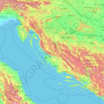
Name: Croatia topographic map, elevation, terrain.
Location: Croatia (42.17660 13.21048 46.55503 19.44727)
Average elevation: 323 m
Minimum elevation: -5 m
Maximum elevation: 2,616 m
Make a donation
Gear up for your next adventure:
As an Amazon Associate, this site earns from qualifying purchases at no extra cost to you.
Other topographic maps
Click on a map to view its topography, its elevation and its terrain.
Tbilisi
Most of the raions are named after historic quarters of the city. The citizens of Tbilisi widely recognise an informal system of smaller historic neighbourhoods. Such neighbourhoods are several, however, constituting a kind of hierarchy, because most of them have lost their distinctive topographic limits. The…
Average elevation: 713 m
Make a donation
Gear up for your next adventure:
As an Amazon Associate, this site earns from qualifying purchases at no extra cost to you.
Make a donation
Gear up for your next adventure:
As an Amazon Associate, this site earns from qualifying purchases at no extra cost to you.
Make a donation
Gear up for your next adventure:
As an Amazon Associate, this site earns from qualifying purchases at no extra cost to you.
Make a donation
Gear up for your next adventure:
As an Amazon Associate, this site earns from qualifying purchases at no extra cost to you.
Make a donation
Gear up for your next adventure:
As an Amazon Associate, this site earns from qualifying purchases at no extra cost to you.
Make a donation
Gear up for your next adventure:
As an Amazon Associate, this site earns from qualifying purchases at no extra cost to you.
Make a donation
Gear up for your next adventure:
As an Amazon Associate, this site earns from qualifying purchases at no extra cost to you.
Make a donation
Gear up for your next adventure:
As an Amazon Associate, this site earns from qualifying purchases at no extra cost to you.
Make a donation
Gear up for your next adventure:
As an Amazon Associate, this site earns from qualifying purchases at no extra cost to you.
Make a donation
Gear up for your next adventure:
As an Amazon Associate, this site earns from qualifying purchases at no extra cost to you.
Kgaswane Mountain Nature Reserve
South Africa > North West > Bojanala Platinum District Municipality > Rustenburg Local Municipality
Average elevation: 1,307 m
Make a donation
Gear up for your next adventure:
As an Amazon Associate, this site earns from qualifying purchases at no extra cost to you.
Make a donation
Gear up for your next adventure:
As an Amazon Associate, this site earns from qualifying purchases at no extra cost to you.
Musandam
The rugged coastline resembles the glacier-carved coasts of polar regions, but in this case, the coast was shaped by the movement of Earth's crust. The Arabian Plate is slowly pushing under the Eurasian Plate, creating the earthquake-prone mountains of Iran. On the leading edge of the Arabian Plate, the…
Average elevation: 254 m
Make a donation
Gear up for your next adventure:
As an Amazon Associate, this site earns from qualifying purchases at no extra cost to you.
Make a donation
Gear up for your next adventure:
As an Amazon Associate, this site earns from qualifying purchases at no extra cost to you.
Make a donation
Gear up for your next adventure:
As an Amazon Associate, this site earns from qualifying purchases at no extra cost to you.
Europe
Europe's topography is characterized by a striking contrast between its rugged southern mountains and the expansive plains of the north. The continent is often described as a "peninsula of peninsulas," featuring major peninsulas like the Iberian, Italian, and Balkan, each with unique geological features. In…
Average elevation: 223 m
Make a donation
Gear up for your next adventure:
As an Amazon Associate, this site earns from qualifying purchases at no extra cost to you.
Make a donation
Gear up for your next adventure:
As an Amazon Associate, this site earns from qualifying purchases at no extra cost to you.
Make a donation
Gear up for your next adventure:
As an Amazon Associate, this site earns from qualifying purchases at no extra cost to you.
Make a donation
Gear up for your next adventure:
As an Amazon Associate, this site earns from qualifying purchases at no extra cost to you.
Great Skellig
The island is of special interest to archaeologists, as the monastic settlement is in unusually good condition. The monastery on the northern peak is situated at an elevation of 170 to 180 m (550 to 600 ft), Christ's Saddle at 129 m (422 ft), and the flagstaff area are 37 m (120 ft) above sea level. The…
Average elevation: 1 m
Make a donation
Gear up for your next adventure:
As an Amazon Associate, this site earns from qualifying purchases at no extra cost to you.
Lambay Island
Lambay Island is the largest island off the east coast of Ireland. It covers about 2.5 km2 (0.97 sq mi). The highest point – a hill known as Knockbane – rises to 126 m (413 ft). The island's high ground lies to the east and aside from Knockbane includes Heath Hill and Tinian Hill, and in the extreme…
Average elevation: 14 m
Make a donation
Gear up for your next adventure:
As an Amazon Associate, this site earns from qualifying purchases at no extra cost to you.
Make a donation
Gear up for your next adventure:
As an Amazon Associate, this site earns from qualifying purchases at no extra cost to you.
Make a donation
Gear up for your next adventure:
As an Amazon Associate, this site earns from qualifying purchases at no extra cost to you.
Make a donation
Gear up for your next adventure:
As an Amazon Associate, this site earns from qualifying purchases at no extra cost to you.
Make a donation
Gear up for your next adventure:
As an Amazon Associate, this site earns from qualifying purchases at no extra cost to you.