
Tataouine topographic map
Interactive map
Click on the map to display elevation.
Tataouine
Wells from aquifers dot the eastern slopes of the pronounced long escarpment climbing gradually from 100 m to 500 m in elevation two provinces north in the south extreme of Gabes Governorate, passing through a thin strip of Medenine and then at the heart of the province ending around a capital city Tripoli, Libya. The ridge attracts variable winter and early spring relief precipitation and little other rain and shares with the rest of the area a hot desert climate (Köppen climate classification BWh) with long, extremely hot summers throughout (see North-south graduation of Tunisian climatic zones), the patchy and infrequent rainfall in winter is greater than the average for the Sahara Desert of which the area forms part. Approximately half of the escarpment exceeds 500 m in the province, the peak within Tunisia being 631 m near the town of Remada on the main road south of Tatouine leading into mid-eastern Libya. The tripoint of the three countries is close to the Libyan town of Ghadames which has surrounding it three airstrips, one of which constitutes an airport and one of which lies in Algeria. Close to the west or south-west border is El Borma Airport and the province has a second, which is for defence and rescue, Remada Air Base.
About this map
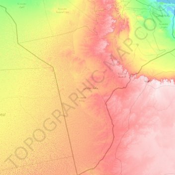
Name: Tataouine topographic map, elevation, terrain.
Location: Tataouine, Tunisia (30.22906 8.35683 33.23475 11.34198)
Average elevation: 295 m
Minimum elevation: -3 m
Maximum elevation: 714 m
Other topographic maps
Click on a map to view its topography, its elevation and its terrain.
Bizerte
Tunisia > Bizerte > بوبكر باكير
The bridge leads to the motorway A4 leading to Tunis–Carthage International Airport and the capital. On the town side the P11 passes semi-rural Louata, hugs Ichkeul Lake and branches into a western route, the P7, leading directly to Tabarka on the coast next to the Algerian border. The P11 leads south-west…
Average elevation: 28 m