
Yunnan topographic map
Interactive map
Click on the map to display elevation.
About this map
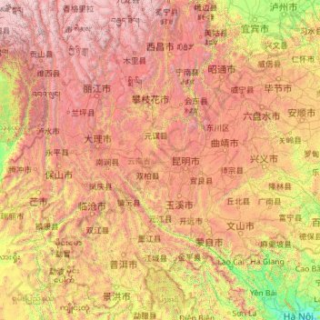
Name: Yunnan topographic map, elevation, terrain.
Location: Yunnan, China (21.14314 97.52746 29.22572 106.19675)
Average elevation: 1,713 m
Minimum elevation: 4 m
Maximum elevation: 6,431 m
Yunnan is situated in a mountainous area, with high elevations in the northwest and low elevations in the southeast. Most of the population lives in the eastern part of the province. In the west, the altitude can vary from the mountain peaks to river valleys by as much as 3,000 m (9,800 ft). Yunnan is rich in natural resources and has the largest diversity of plant life in China. Of the approximately 30,000 species of higher plants in China, Yunnan has perhaps 17,000 or more. Yunnan's reserves of aluminium, lead, zinc and tin are the largest in China, and there are also major reserves of copper and nickel. Historically, the southwestern Silk Road to Bhitargarh in Bangladesh passed through modern Yunnan.
Other topographic maps
Click on a map to view its topography, its elevation and its terrain.
Xingtan
China > Guangdong Province > Shunde District
Xingtan, Shunde District, Foshan, Guangdong Province, China
Average elevation: 4 m
Baiyu
China > Sichuan > Baiyü County > Jianshe
Baiyu, Jianshe, Baiyü County, Kardze, Sichuan, 627100, China
Average elevation: 3,959 m
Gaozhou City
China > Guangdong Province > Maoming City
Gaozhou City, Maoming City, Guangdong Province, 525200, China
Average elevation: 187 m
卡瓦格博观景台
China > Tibet > Zogang County > Pütog
卡瓦格博观景台, 甲应路, Pütog, Zogang County, Chamdo City, Nyingchi Prefecture, Tibet, China
Average elevation: 4,323 m
Tekes
China > Xinjiang > Tekes County
Tekes, Tekes County, Ili, Xinjiang, China
Average elevation: 1,587 m
Linkou County
Linkou County, Mudanjiang City, Heilongjiang, China
Average elevation: 432 m
Chini
China > Guangdong Province > Huadu District
Chini, Huadu District, Guangzhou City, Guangdong Province, China
Average elevation: 30 m
Macau
China > Macau > São Lourenço
Macau, São Lourenço, Municipality of Macau, Macau, 519020, China
Average elevation: 17 m
Chengguan District
Chengguan District, Lhasa, Tibet, 850000, China
Average elevation: 4,325 m
Nanguan District
China > Jilin > Changchun City
Nanguan District, Changchun City, Jilin, 130000, China
Average elevation: 241 m
Kashgar Prefecture
China > Xinjiang > Kashgar City
Kashgar Prefecture, Kashgar City, Kashgar Prefecture, Xinjiang, 844000, China
Average elevation: 2,275 m
Danba
China > Sichuan > Danba County
Danba, Danba County, Kardze Tibetan Autonomous Prefecture, Sichuan, China
Average elevation: 3,257 m
Chongchuan District
Chongchuan District, Nantong, Jiangsu, 226000, China
Average elevation: 3 m
Guzai
China > Guangxi > Du'an Yao Autonomous County
Guzai, Du'an Yao Autonomous County, Hechi, Guangxi, China
Average elevation: 152 m
Goujie
China > Yunnan > Yiliang County
Goujie, Yiliang County, Yunnan, China
Average elevation: 1,810 m
Gaohong
China > Zhejiang > Lin'an District
Gaohong, Lin'an District, Hangzhou City, Zhejiang, China
Average elevation: 282 m
Sha
China > Fujian > Fenggang Subdistrict
Sha, Fenggang Subdistrict, Shaxian District, Sanming City, Fujian, 365500, China
Average elevation: 397 m
Keli
China > Fujian > Datian County
Keli, Datian County, Sanming City, Fujian, China
Average elevation: 721 m
Northeast China
China > Heilongjiang > Harbin
Northeast China, Harbin, Heilongjiang, China
Average elevation: 244 m
Shigatse
China > Tibet > Chengdong Subdistrict
Shigatse, Chengdong Subdistrict, Samzhubzê District, Shigatse Prefecture, Tibet, China
Average elevation: 4,055 m
Qingshui River
China > Hebei > Zhangjiakou City > 闫家屯村
Qingshui River, 闫家屯村, Zhangjiakou City, Hebei, 075000, China
Average elevation: 781 m