
Make a donation
Gear up for your next adventure:
As an Amazon Associate, this site earns from qualifying purchases at no extra cost to you.
Zhejiang topographic map
Click on the map to display elevation.
Make a donation
Gear up for your next adventure:
As an Amazon Associate, this site earns from qualifying purchases at no extra cost to you.
Zhejiang
Zhejiang consists mostly of hills, which account for about 70% of its total area, with higher altitudes towards the south and the west. Zhejiang also has a longer coastline than any other mainland province of China. The Qiantang River runs through the province, from which it derives its name. Included in the province are three thousand islands, the most in China. The capital Hangzhou marks the end of the Grand Canal and lies on Hangzhou Bay on the north of Zhejiang, which separates Shanghai and Ningbo. The bay contains many small islands collectively called the Zhoushan Islands.
Make a donation
Gear up for your next adventure:
As an Amazon Associate, this site earns from qualifying purchases at no extra cost to you.
About this map
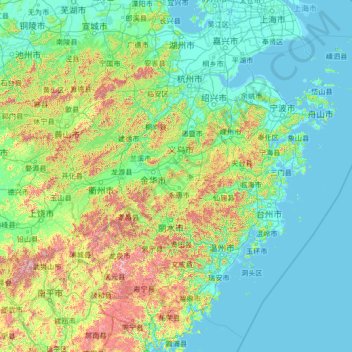
Name: Zhejiang topographic map, elevation, terrain.
Location: Zhejiang, China (26.85910 118.02241 31.18258 123.39362)
Average elevation: 223 m
Minimum elevation: -2 m
Maximum elevation: 2,037 m
Make a donation
Gear up for your next adventure:
As an Amazon Associate, this site earns from qualifying purchases at no extra cost to you.
Other topographic maps
Click on a map to view its topography, its elevation and its terrain.
Chongqing Yunyang Longgang National Geopark
China > Chongqing > Yunyang County
Average elevation: 832 m
Zhangye Danxia National Geological Park
China > Gansu > Sunan Yugur Autonomous County
The core area of the park, Linze Danxia Scenic Area, is located 30 kilometres (19 mi) west of downtown Zhangye and 20 kilometres (12 mi) south of the seat of Linze County. It is the most developed and most visited part of the park. A second scenic area, Binggou (冰沟), located on the north bank of Liyuan…
Average elevation: 1,759 m
Make a donation
Gear up for your next adventure:
As an Amazon Associate, this site earns from qualifying purchases at no extra cost to you.
Make a donation
Gear up for your next adventure:
As an Amazon Associate, this site earns from qualifying purchases at no extra cost to you.
Shanghai
The golden age of Shanghai began with its elevation to municipality after it was separated from Jiangsu on 7 July 1927. This new Chinese municipality covered an area of 494.69 km2 (191.0 sq mi), including the modern-day districts of Baoshan, Yangpu, Zhabei, Nanshi, and Pudong, but excluded the foreign…
Average elevation: 5 m
Chongqing
The central urban area of Chongqing, or Chongqing proper, is a city of unique features. Built on mountains and partially surrounded by the Yangtze and Jialing rivers, it is known as a "mountain city" and a "city on rivers". The night scene of the city is very illuminated, with millions of lights and their…
Average elevation: 318 m
Make a donation
Gear up for your next adventure:
As an Amazon Associate, this site earns from qualifying purchases at no extra cost to you.
Beijing
Beijing is situated at the northern tip of the roughly triangular North China Plain, which opens to the south and east of the city. Mountains to the north, northwest and west shield the city and northern China's agricultural heartland from the encroaching desert steppes. The northwestern part of the…
Average elevation: 47 m
Mischief Reef
China > Hainan Province > Sansha
Mischief Reef, also known as Panganiban Reef (Filipino: Bahura ng Panganiban; Vietnamese: Đá Vành Khăn; Mandarin Chinese: 美濟礁/美济礁; pinyin: Měijì Jiāo; lit. 'Meiji Reef'), is a low tide elevation (LTE) reef/atoll surrounding a large lagoon in the SE of Dangerous Ground in the east of the…
Average elevation: 0 m
Subi Reef
China > Hainan Province > Nansha District
On 12 July 2016, the UNCLOS special arbitral tribunal in the Philippines v. China case confirmed that Subi Reef is, or in its natural condition was, exposed at low tide and submerged at high tide and is, accordingly a low-tide elevation that does not generate entitlement to a territorial sea, exclusive…
Average elevation: 0 m
Make a donation
Gear up for your next adventure:
As an Amazon Associate, this site earns from qualifying purchases at no extra cost to you.
Make a donation
Gear up for your next adventure:
As an Amazon Associate, this site earns from qualifying purchases at no extra cost to you.
Shigatse
China > Tibet > Chengdong Subdistrict
Shigatse Peace Airport began operations on 30 October 2010 after an Airbus A319 landed safely, making it Tibet's fifth commercial airport. It is located 43 kilometres from Samzhubzê District at Jangdam Township at an elevation of 3,782 metres. The airport will be capable of supporting 230,000 passengers…
Average elevation: 4,055 m
Make a donation
Gear up for your next adventure:
As an Amazon Associate, this site earns from qualifying purchases at no extra cost to you.
Make a donation
Gear up for your next adventure:
As an Amazon Associate, this site earns from qualifying purchases at no extra cost to you.