
Tsona County topographic map
Interactive map
Click on the map to display elevation.
About this map
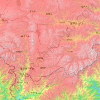
Name: Tsona County topographic map, elevation, terrain.
Location: Tsona County, Shannan, Tibet, China (27.71649 91.39785 28.46401 92.73770)
Average elevation: 4,470 m
Minimum elevation: 1,150 m
Maximum elevation: 6,998 m
Other topographic maps
Click on a map to view its topography, its elevation and its terrain.
Shigatse
China > Tibet > Chengdong Subdistrict
Shigatse Peace Airport began operations on 30 October 2010 after an Airbus A319 landed safely, making it Tibet's fifth commercial airport. It is located 43 kilometres from Samzhubzê District at Jangdam Township at an elevation of 3,782 metres. The airport will be capable of supporting 230,000 passengers…
Average elevation: 4,055 m