
Sichuan topographic map
Interactive map
Click on the map to display elevation.
About this map
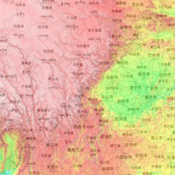
Name: Sichuan topographic map, elevation, terrain.
Location: Sichuan, China (26.04817 97.34738 34.31471 108.54267)
Average elevation: 2,522 m
Minimum elevation: 140 m
Maximum elevation: 6,536 m
Due to great differences in terrain, the climate of the province is highly variable. In general, it has strong monsoonal influences, with rainfall heavily concentrated in the summer. Under the Köppen climate classification, the Sichuan Basin (including Chengdu) in the eastern half of the province experiences a humid subtropical climate (Köppen Cwa or Cfa), with long, hot, wet summers and short, mild to cool, dry, and cloudy winters. Consequently, it has China's lowest sunshine totals. The western region has mountainous areas producing a cooler but sunnier climate. Having cool to very cold winters and mild summers, temperatures generally decrease with greater elevation. However, due to its high altitude and its inland location, many areas such as Garze County and Zoige County in Sichuan exhibit a subarctic climate (Köppen Dwc)- featuring extremely cold winters down to −30 °C and even cold summer nights. The region is geologically active with landslides and earthquakes. Average elevation ranges from 2,000 to 3,500 meters; average temperatures range from 0 to 15 °C. The southern part of the province, including Panzhihua and Xichang, has a sunny climate with short, very mild winters and very warm to hot summers.
Other topographic maps
Click on a map to view its topography, its elevation and its terrain.
Xingtan
China > Guangdong Province > Shunde District
Xingtan, Shunde District, Foshan, Guangdong Province, China
Average elevation: 4 m
Baiyu
China > Sichuan > Baiyü County > Jianshe
Baiyu, Jianshe, Baiyü County, Kardze, Sichuan, 627100, China
Average elevation: 3,959 m
Gaozhou City
China > Guangdong Province > Maoming City
Gaozhou City, Maoming City, Guangdong Province, 525200, China
Average elevation: 187 m
卡瓦格博观景台
China > Tibet > Zogang County > Pütog
卡瓦格博观景台, 甲应路, Pütog, Zogang County, Chamdo City, Nyingchi Prefecture, Tibet, China
Average elevation: 4,323 m
Tekes
China > Xinjiang > Tekes County
Tekes, Tekes County, Ili, Xinjiang, China
Average elevation: 1,587 m
Linkou County
Linkou County, Mudanjiang City, Heilongjiang, China
Average elevation: 432 m
Chini
China > Guangdong Province > Huadu District
Chini, Huadu District, Guangzhou City, Guangdong Province, China
Average elevation: 30 m
Macau
China > Macau > São Lourenço
Macau, São Lourenço, Municipality of Macau, Macau, 519020, China
Average elevation: 17 m
Chengguan District
Chengguan District, Lhasa, Tibet, 850000, China
Average elevation: 4,325 m
Nanguan District
China > Jilin > Changchun City
Nanguan District, Changchun City, Jilin, 130000, China
Average elevation: 241 m
Kashgar Prefecture
China > Xinjiang > Kashgar City
Kashgar Prefecture, Kashgar City, Kashgar Prefecture, Xinjiang, 844000, China
Average elevation: 2,275 m
Danba
China > Sichuan > Danba County
Danba, Danba County, Kardze Tibetan Autonomous Prefecture, Sichuan, China
Average elevation: 3,257 m
Chongchuan District
Chongchuan District, Nantong, Jiangsu, 226000, China
Average elevation: 3 m
Guzai
China > Guangxi > Du'an Yao Autonomous County
Guzai, Du'an Yao Autonomous County, Hechi, Guangxi, China
Average elevation: 152 m
Goujie
China > Yunnan > Yiliang County
Goujie, Yiliang County, Yunnan, China
Average elevation: 1,810 m
Gaohong
China > Zhejiang > Lin'an District
Gaohong, Lin'an District, Hangzhou City, Zhejiang, China
Average elevation: 282 m
Sha
China > Fujian > Fenggang Subdistrict
Sha, Fenggang Subdistrict, Shaxian District, Sanming City, Fujian, 365500, China
Average elevation: 397 m
Keli
China > Fujian > Datian County
Keli, Datian County, Sanming City, Fujian, China
Average elevation: 721 m
Northeast China
China > Heilongjiang > Harbin
Northeast China, Harbin, Heilongjiang, China
Average elevation: 244 m
Shigatse
China > Tibet > Chengdong Subdistrict
Shigatse, Chengdong Subdistrict, Samzhubzê District, Shigatse Prefecture, Tibet, China
Average elevation: 4,055 m
Qingshui River
China > Hebei > Zhangjiakou City > 闫家屯村
Qingshui River, 闫家屯村, Zhangjiakou City, Hebei, 075000, China
Average elevation: 781 m