
Cambodia topographic map
Interactive map
Click on the map to display elevation.
About this map
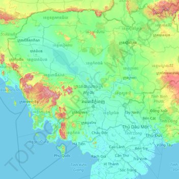
Name: Cambodia topographic map, elevation, terrain.
Location: Cambodia (9.41110 102.33383 14.69042 107.62768)
Average elevation: 97 m
Minimum elevation: -2 m
Maximum elevation: 1,599 m
Cambodia's landscape is characterised by a low-lying central plain that is surrounded by uplands and low mountains and includes the Tonle Sap (Great Lake) and the upper reaches of the Mekong River delta. Extending outward from this central region are transitional plains, thinly forested and rising to elevations of about 650 feet (200 metres) above sea level.
Other topographic maps
Click on a map to view its topography, its elevation and its terrain.
Ireland
Ireland
Average elevation: 44 m
Chasiv Yar
Chasiv Yar, Chasiv Yar urban hromada, Bakhmut Raion, Donetsk Oblast, 84551-84556, Ukraine
Average elevation: 213 m
Croatia
Croatia
Average elevation: 323 m
High Wycombe
United Kingdom > England > Buckinghamshire
High Wycombe, Buckinghamshire, England, United Kingdom
Average elevation: 124 m
Europe
Europe
Average elevation: 223 m
Czechia
Czechia
Average elevation: 369 m
Carranstown
Carranstown, Duleek ED, The Municipal District of Laytown — Bettystown, County Meath, Leinster, Ireland
Average elevation: 36 m
Catahoula Parish
Catahoula Parish, Louisiana, United States
Average elevation: 24 m
Cornwall
United Kingdom > England > Fairy Cross
Cornwall, Broadoak, Fairy Cross, Cornwall, South West England, England, United Kingdom
Average elevation: 49 m
Bangladesh
Bangladesh
Average elevation: 161 m
Monterey County
Monterey County, California, United States
Average elevation: 282 m
Victorville
United States > California > San Bernardino County
Victorville, San Bernardino County, California, United States
Average elevation: 920 m
Galway City
Galway, Galway City, County Galway, Connacht, H91 YD86, Ireland
Average elevation: 26 m
Valencia
Spain > Valencian Community > Comarca de València
Valencia, Comarca de València, Valencia, Valencian Community, Spain
Average elevation: 37 m
Taiwan
Taiwan > Taiwan Province > Xinyi Township
Taiwan, Xinyi Township, Nantou County, Taiwan Province, Taiwan
Average elevation: 196 m
Madagascar
Madagascar
Average elevation: 139 m
Latvia
Latvia
Average elevation: 72 m
Cork
Ireland > County Cork > Cork
Cork, County Cork, Munster, T12 T997, Ireland
Average elevation: 94 m
Avonmore
Canada > Ontario > Stormont, Dundas and Glengarry Counties > North Stormont
Avonmore, North Stormont, Stormont, Dundas and Glengarry Counties, Eastern Ontario, Ontario, K0C 1C0, Canada
Average elevation: 95 m
Mother Nature's Crack
United States > Missouri > Newton County > Joplin > Cliff Village
Mother Nature's Crack, Cliff Village, Joplin, Newton County, Missouri, 64804, United States
Average elevation: 296 m
Primm
United States > Nevada > Clark County
Primm, Clark County, Nevada, United States
Average elevation: 817 m
Rattlesnake Lake
United States > Washington > Adams County
Rattlesnake Lake, Adams County, Washington, United States
Average elevation: 468 m
Cedar Falls
United States > Washington > Okanogan County
Cedar Falls, Okanogan County, Washington, United States
Average elevation: 1,375 m
Pachalik de Benguerir باشوية ابن جرير
Pachalik de Benguerir باشوية ابن جرير, Rhamna Province, Marrakech-Safi, Morocco
Average elevation: 473 m
Aghamore
Aghamore, Claremorris-Swinford Municipal District, County Mayo, Connacht, Ireland
Average elevation: 111 m
Tooele County
United States of America > Utah
Tooele County, Utah, United States of America
Average elevation: 1,462 m
San Bernardino County
San Bernardino County, California, United States
Average elevation: 763 m
Middlefield
United States > Ohio > Geauga County
Middlefield, Middlefield Township, Geauga County, Ohio, 44062, United States
Average elevation: 351 m