
手形字山崎 topographic map
Interactive map
Click on the map to display elevation.
About this map
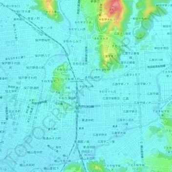
Name: 手形字山崎 topographic map, elevation, terrain.
Location: 手形字山崎, 秋田市, 秋田县, 010-0854, 日本 (39.70181 140.11248 39.74181 140.15248)
Average elevation: 15 m
Minimum elevation: 4 m
Maximum elevation: 93 m
Other topographic maps
Click on a map to view its topography, its elevation and its terrain.