
土崎港古川町字古川添下 topographic map
Interactive map
Click on the map to display elevation.
About this map
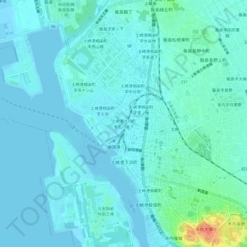
Name: 土崎港古川町字古川添下 topographic map, elevation, terrain.
Location: 土崎港古川町字古川添下, 秋田市, 秋田县, 011-0945, 日本 (39.73843 140.04297 39.77843 140.08297)
Average elevation: 8 m
Minimum elevation: -1 m
Maximum elevation: 54 m
Other topographic maps
Click on a map to view its topography, its elevation and its terrain.