
Death Valley topographic map
Interactive map
Click on the map to display elevation.
About this map
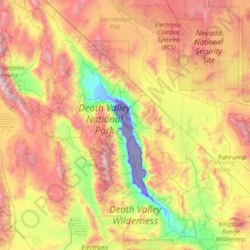
Name: Death Valley topographic map, elevation, terrain.
Location: Death Valley, California, 92328, United States (35.55151 -117.65105 37.29602 -116.25764)
Average elevation: 1,085 m
Minimum elevation: -83 m
Maximum elevation: 3,329 m
Death Valley's Badwater Basin is the point of lowest elevation in North America, at 282 feet (86 m) below sea level. It is 84.6 miles (136.2 km) east-southeast of Mount Whitney — the highest point in the contiguous United States, with an elevation of 14,505 feet (4,421 m). On the afternoon of July 10, 1913, the United States Weather Bureau recorded a high temperature of 134 °F (56.7 °C) at Furnace Creek in Death Valley, which stands as the highest ambient air temperature ever recorded on the surface of the Earth. This reading, however, and several others taken in that period are disputed by some modern experts.
Other topographic maps
Click on a map to view its topography, its elevation and its terrain.
Monterey County
Monterey County, California, United States
Average elevation: 282 m
El Dorado County
El Dorado County, California, United States
Average elevation: 1,286 m
Victorville
United States > California > San Bernardino County
Victorville, San Bernardino County, California, United States
Average elevation: 920 m
San Bernardino County
San Bernardino County, California, United States
Average elevation: 763 m
Chino
United States > California > San Bernardino County
Chino, San Bernardino County, California, United States
Average elevation: 239 m
Serrano Village
United States > California > San Bernardino County > San Bernardino
Serrano Village, San Bernardino, San Bernardino County, California, 92405, United States
Average elevation: 489 m
San Diego
United States > California > San Diego County
San Diego, San Diego County, California, United States
Average elevation: 125 m
Visalia
United States > California > Tulare County
Visalia, Tulare County, California, United States
Average elevation: 102 m
Fontana
United States > California > San Bernardino County
Fontana, San Bernardino County, California, United States
Average elevation: 414 m
Beverly Hills
United States > California > Los Angeles County
Beverly Hills, Los Angeles County, California, United States
Average elevation: 144 m
Oak Glen
United States > California > San Bernardino County
Oak Glen, San Bernardino County, California, 92339, United States
Average elevation: 1,610 m
Henningsen Lotus Park
United States > California > El Dorado County > Lotus
Henningsen Lotus Park, Lotus, El Dorado County, California, United States
Average elevation: 261 m
Joshua Tree
United States > California > San Bernardino County
Joshua Tree, San Bernardino County, California, United States
Average elevation: 1,010 m
Drakes Point
United States > California > Solano County > Vacaville
Drakes Point, Vacaville, Solano County, California, 95688, United States
Average elevation: 77 m
Rialto
United States > California > San Bernardino County
Rialto, San Bernardino County, California, United States
Average elevation: 391 m
Apple Valley
United States > California > San Bernardino County
Apple Valley, San Bernardino County, California, United States
Average elevation: 977 m
San Jose
United States > California > Santa Clara County
San Jose, Santa Clara County, California, United States
Average elevation: 264 m
Los Angeles County
Los Angeles County, California, 91023, United States, Mount Wilson
Average elevation: 1,434 m
Roseville
United States > California > Placer County
Roseville, Placer County, California, United States
Average elevation: 61 m
El Toro Lake
United States > California > Monterey County
El Toro Lake, Monterey County, California, United States
Average elevation: 176 m
Pacifica
United States > California > San Mateo County
Pacifica, San Mateo County, CAL Fire Northern Region, California, 94044, United States
Average elevation: 76 m
Cupertino
United States > California > Santa Clara County
Cupertino, Santa Clara County, California, 95014, United States
Average elevation: 102 m
Pollock Pines
United States > California > El Dorado County > Pollock Pines
Pollock Pines, El Dorado County, California, 95726, United States
Average elevation: 1,118 m
Lake Hills Estates
United States > California > El Dorado County
Lake Hills Estates, El Dorado County, California, United States
Average elevation: 176 m
Moro Rock
United States > California > Tulare County
Moro Rock, Tulare County, California, United States
Average elevation: 1,628 m
Fillmore
United States > California > Ventura County
Fillmore, Ventura County, CAL Fire Contract Counties, California, 93016, United States
Average elevation: 181 m
Agoura Hills
United States > California > Los Angeles County
Agoura Hills, Los Angeles County, CAL Fire Southern Region, California, 91301, United States
Average elevation: 333 m
San Bernardino
United States > California > San Bernardino County
San Bernardino, San Bernardino County, California, United States
Average elevation: 662 m
Indian Wells
United States > California > Riverside County
Indian Wells, Riverside County, CAL Fire Southern Region, California, 92210, United States
Average elevation: 118 m
Foresthill
United States > California > Placer County
Foresthill, Placer County, California, 95631, United States
Average elevation: 749 m
Mendocino County
Mendocino County, CAL Fire Northern Region, California, United States
Average elevation: 486 m
Twentynine Palms
United States > California > San Bernardino County
Twentynine Palms, San Bernardino County, California, 92278, United States
Average elevation: 690 m
Arcadia
United States > California > Los Angeles County
Arcadia, Los Angeles County, CAL Fire Contract Counties, California, United States
Average elevation: 184 m
El Dorado Hills
United States > California > El Dorado County > Folsom
El Dorado Hills, Folsom, El Dorado County, CAL Fire Northern Region, California, 95762, United States
Average elevation: 243 m
Soledad
United States > California > Monterey County > Soledad
Soledad, Monterey County, CAL Fire Southern Region, California, 93960, United States
Average elevation: 64 m
Santa Maria
United States > California > Santa Barbara County
Santa Maria, Santa Barbara County, CAL Fire Southern Region, California, United States
Average elevation: 86 m
Stockton
United States > California > San Joaquin County
Stockton, San Joaquin County, California, United States
Average elevation: 7 m
Pine Mountain Club
United States > California > Kern County
Pine Mountain Club, Kern County, CAL Fire Southern Region, California, 93222, United States
Average elevation: 1,867 m
Pinnacles National Park
United States > California > San Benito County
Pinnacles National Park, San Benito County, California, United States
Average elevation: 495 m
Channel Islands
United States > California > Santa Barbara County
Channel Islands, Santa Barbara County, CAL Fire Southern Region, California, 90704, United States
Average elevation: 4 m
Coto de Caza
United States > California > Orange County
Coto de Caza, Orange County, CAL Fire Southern Region, California, 92679, United States
Average elevation: 267 m
Redwood National Park
United States > California > Del Norte County
Redwood National Park, Del Norte County, CAL Fire Northern Region, California, United States
Average elevation: 367 m
Orinda
United States > California > Contra Costa County
Orinda, Contra Costa County, CAL Fire Northern Region, California, 94563, United States
Average elevation: 246 m
The Fingers
United States > California > San Benito County
The Fingers, San Benito County, California, United States
Average elevation: 575 m
Hesperia
United States > California > San Bernardino County
Hesperia, San Bernardino County, California, United States
Average elevation: 1,027 m
San Benito County
San Benito County, California, United States
Average elevation: 454 m
Alta Peak
United States > California > San Benito County
Alta Peak, San Benito County, California, United States
Average elevation: 1,298 m
Clouds Rest
United States > California > Mariposa County
Clouds Rest, Mariposa County, California, United States
Average elevation: 2,547 m
Mount Ericsson
United States > California > Tulare County
Mount Ericsson, Tulare County, California, United States
Average elevation: 3,707 m
Three Rivers
United States > California > Tulare County
Three Rivers, Tulare County, California, United States
Average elevation: 661 m