
Make a donation
Gear up for your next adventure:
As an Amazon Associate, this site earns from qualifying purchases at no extra cost to you.
Clouds Rest topographic map
Click on the map to display elevation.
Make a donation
Gear up for your next adventure:
As an Amazon Associate, this site earns from qualifying purchases at no extra cost to you.
About this map
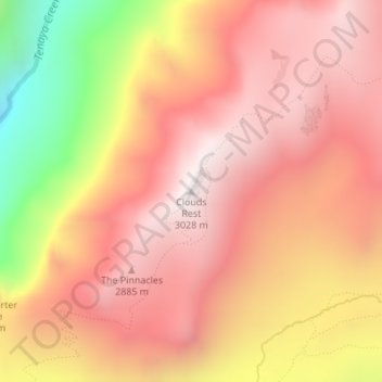
Name: Clouds Rest topographic map, elevation, terrain.
Location: Clouds Rest, Mariposa County, California, United States (37.76779 -119.48930 37.76789 -119.48920)
Average elevation: 2,547 m
Minimum elevation: 1,708 m
Maximum elevation: 2,991 m
Make a donation
Gear up for your next adventure:
As an Amazon Associate, this site earns from qualifying purchases at no extra cost to you.
Other topographic maps
Click on a map to view its topography, its elevation and its terrain.
Yosemite Valley
United States > California > Mariposa County > Yosemite Village
Average elevation: 2,016 m
Yosemite National Park
United States > California > Mariposa County
Its geology is characterized by granite and remnants of older rock. About 10 million years ago, the Sierra Nevada was uplifted and tilted to form its unique slopes, which increased the steepness of stream and river beds, forming deep, narrow canyons. About one million years ago glaciers formed at higher…
Average elevation: 2,337 m