
Channel Islands topographic map
Click on the map to display elevation.
Channel Islands
The Channel Islands at low elevations are virtually frost-free and constitute one of the few such areas in the 48 contiguous US states. It snows only rarely, on higher mountain peaks.
About this map
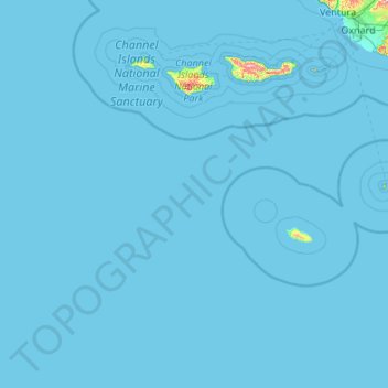
Name: Channel Islands topographic map, elevation, terrain.
Average elevation: 4 m
Minimum elevation: 0 m
Maximum elevation: 689 m
Other topographic maps
Click on a map to view its topography, its elevation and its terrain.
Hope Ranch
United States > California > Santa Barbara County
Hope Ranch occupies a hilly area immediately adjacent to the coast; the highest elevation is 691 feet (211 m). The northern boundary of the hilly area is Cieneguitas Creek, which flows down the topographic expression of the More Ranch Fault; this ravine also helps define the informal northern boundary of the…
Average elevation: 43 m