
Hope Ranch topographic map
Click on the map to display elevation.
Hope Ranch
Hope Ranch occupies a hilly area immediately adjacent to the coast; the highest elevation is 691 feet (211 m). The northern boundary of the hilly area is Cieneguitas Creek, which flows down the topographic expression of the More Ranch Fault; this ravine also helps define the informal northern boundary of the suburb. Native vegetation is mostly California oak woodland and chaparral, and many of the homes have been constructed to blend in with the oaks; the area retains much of its tree canopy. Residential roads are narrow and winding, not always signed, and interweave with an elaborate network of horse paths. A road to a private beach is open to residents only (although the beach itself is accessible from public beaches on either side).
About this map
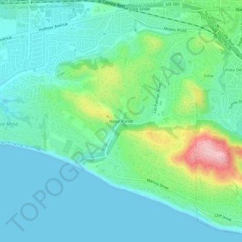
Name: Hope Ranch topographic map, elevation, terrain.
Average elevation: 43 m
Minimum elevation: 0 m
Maximum elevation: 185 m
Other topographic maps
Click on a map to view its topography, its elevation and its terrain.
Channel Islands
United States > California > Santa Barbara County
The Channel Islands at low elevations are virtually frost-free and constitute one of the few such areas in the 48 contiguous US states. It snows only rarely, on higher mountain peaks.
Average elevation: 4 m