
Make a donation
Gear up for your next adventure:
As an Amazon Associate, this site earns from qualifying purchases at no extra cost to you.
Rialto topographic map
Click on the map to display elevation.
Make a donation
Gear up for your next adventure:
As an Amazon Associate, this site earns from qualifying purchases at no extra cost to you.
Rialto
The particularly arid climate during the summer prevents tropospheric clouds from forming, meaning temperatures rise to what is considered Class Orange by NOAA. Rialto gets an average of 16 inches (410 mm) of rain, and most of this rainfall precipitates in winter. During winter, Rialto's northernmost neighborhood gets snow, heavily at times as a result of its elevation of about 3,000 feet (910 m) above sea level. However, most of the city is out of snowfall's path.
Make a donation
Gear up for your next adventure:
As an Amazon Associate, this site earns from qualifying purchases at no extra cost to you.
About this map
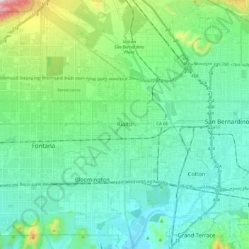
Name: Rialto topographic map, elevation, terrain.
Location: Rialto, San Bernardino County, California, United States (34.02459 -117.43679 34.18715 -117.34104)
Average elevation: 391 m
Minimum elevation: 254 m
Maximum elevation: 945 m
Make a donation
Gear up for your next adventure:
As an Amazon Associate, this site earns from qualifying purchases at no extra cost to you.
Other topographic maps
Click on a map to view its topography, its elevation and its terrain.
Serrano Village
United States > California > San Bernardino County > San Bernardino
Average elevation: 489 m