
Make a donation
Gear up for your next adventure:
As an Amazon Associate, this site earns from qualifying purchases at no extra cost to you.
Hesperia topographic map
Click on the map to display elevation.
Make a donation
Gear up for your next adventure:
As an Amazon Associate, this site earns from qualifying purchases at no extra cost to you.
Hesperia
Hesperia is a city in San Bernardino County, California, United States. It is located 35 miles (56 km) north of downtown San Bernardino in Victor Valley and surrounded by the Mojave Desert. Because of its relatively high elevation and the unique and moderate weather patterns of the region, Hesperia is part of what is locally called the High Desert. The name "Hesperia" means "western land". The 2019 census report estimates that the city has a population of 95,750.
Make a donation
Gear up for your next adventure:
As an Amazon Associate, this site earns from qualifying purchases at no extra cost to you.
About this map
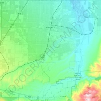
Name: Hesperia topographic map, elevation, terrain.
Location: Hesperia, San Bernardino County, California, United States (34.30424 -117.43987 34.47140 -117.23776)
Average elevation: 1,027 m
Minimum elevation: 859 m
Maximum elevation: 1,720 m
Make a donation
Gear up for your next adventure:
As an Amazon Associate, this site earns from qualifying purchases at no extra cost to you.
Other topographic maps
Click on a map to view its topography, its elevation and its terrain.
Make a donation
Gear up for your next adventure:
As an Amazon Associate, this site earns from qualifying purchases at no extra cost to you.
Cedar Glen
United States > California > San Bernardino County > Lake Arrowhead
Average elevation: 1,640 m
Make a donation
Gear up for your next adventure:
As an Amazon Associate, this site earns from qualifying purchases at no extra cost to you.
Meadowbrook Woods
United States > California > San Bernardino County > Lake Arrowhead
Average elevation: 1,560 m
Running Springs
United States > California > San Bernardino County > Running Springs
Running Springs is a mountain community in the San Bernardino Mountains. It is an inholding in the San Bernardino National Forest. Situated at the junction of State Route 18 and State Route 330, it is a major gateway to the mountain communities of Lake Arrowhead, Arrowbear, Green Valley Lake, and Big Bear and…
Average elevation: 1,656 m
Cajon Pass
United States > California > San Bernardino County
Cajon Pass (/kəˈhoʊn/; Spanish: Puerto del Cajón or Paso del Cajón) is a mountain pass between the San Bernardino Mountains to the east and the San Gabriel Mountains to the west in Southern California. Created by the movements of the San Andreas Fault, it has an elevation of 3,777 ft (1,151 m). Located in…
Average elevation: 1,169 m
Make a donation
Gear up for your next adventure:
As an Amazon Associate, this site earns from qualifying purchases at no extra cost to you.
Devil Canyon
United States > California > San Bernardino County > San Bernardino
Average elevation: 628 m
East Colton Heights
United States > California > San Bernardino County > Colton
Average elevation: 326 m
Make a donation
Gear up for your next adventure:
As an Amazon Associate, this site earns from qualifying purchases at no extra cost to you.
San Gorgonio Mountain
United States > California > San Bernardino County
Since it is the highest point in a region which is separated from higher peaks (e.g. in the Sierra Nevada) by relatively low terrain, San Gorgonio Mountain is one of the most topographically prominent peaks in the United States. It is ranked 7th among peaks in the 48 contiguous states and 18th overall.
Average elevation: 3,154 m
Los Serranos
United States > California > San Bernardino County > Chino Hills
Average elevation: 212 m
Make a donation
Gear up for your next adventure:
As an Amazon Associate, this site earns from qualifying purchases at no extra cost to you.
Arrowbear Lake
United States > California > San Bernardino County > Running Springs
Arrowbear Lake is an unincorporated community in San Bernardino County, California, United States. Its altitude is 6,086 feet (1,855 m) in the San Bernardino Mountains. It is located east of Running Springs along Highway 18 in the San Bernardino National Forest, a mountain community with a population of 736 in…
Average elevation: 1,928 m
Make a donation
Gear up for your next adventure:
As an Amazon Associate, this site earns from qualifying purchases at no extra cost to you.
Moonridge
United States > California > San Bernardino County > Big Bear Lake
Average elevation: 2,211 m
Running Springs
United States > California > San Bernardino County
Running Springs is a mountain community in the San Bernardino Mountains. It is an inholding in the San Bernardino National Forest. Situated at the junction of State Route 18 and State Route 330, it is a major gateway to the mountain communities of Lake Arrowhead, Arrowbear, Green Valley Lake, and Big Bear and…
Average elevation: 1,673 m
Make a donation
Gear up for your next adventure:
As an Amazon Associate, this site earns from qualifying purchases at no extra cost to you.
Make a donation
Gear up for your next adventure:
As an Amazon Associate, this site earns from qualifying purchases at no extra cost to you.
Cucamonga Peak
United States > California > San Bernardino County
Cucamonga Peak is one of the highest peaks of the San Gabriel Mountains in San Bernardino County, California, with a summit elevation of 8,862 feet (2,701 m). It is within the Cucamonga Wilderness of the San Bernardino National Forest.
Average elevation: 2,240 m
Make a donation
Gear up for your next adventure:
As an Amazon Associate, this site earns from qualifying purchases at no extra cost to you.
Fort Irwin
United States > California > San Bernardino County
Fort Irwin National Training Center (Fort Irwin NTC) is a major training area for the United States military in the Mojave Desert in northern San Bernardino County, California. Fort Irwin is at an average elevation of 2,454 feet (748 m). It is located 37 miles (60 km) northeast of Barstow, in the Calico…
Average elevation: 774 m
Make a donation
Gear up for your next adventure:
As an Amazon Associate, this site earns from qualifying purchases at no extra cost to you.
Make a donation
Gear up for your next adventure:
As an Amazon Associate, this site earns from qualifying purchases at no extra cost to you.
Lake Gregory
United States > California > San Bernardino County > Crestline
Average elevation: 1,452 m
Make a donation
Gear up for your next adventure:
As an Amazon Associate, this site earns from qualifying purchases at no extra cost to you.
Moonridge
United States > California > San Bernardino County > Big Bear Lake
Average elevation: 2,211 m
Make a donation
Gear up for your next adventure:
As an Amazon Associate, this site earns from qualifying purchases at no extra cost to you.
Los Serranos
United States > California > San Bernardino County > Chino Hills
Average elevation: 212 m
Make a donation
Gear up for your next adventure:
As an Amazon Associate, this site earns from qualifying purchases at no extra cost to you.
Make a donation
Gear up for your next adventure:
As an Amazon Associate, this site earns from qualifying purchases at no extra cost to you.
Make a donation
Gear up for your next adventure:
As an Amazon Associate, this site earns from qualifying purchases at no extra cost to you.
Make a donation
Gear up for your next adventure:
As an Amazon Associate, this site earns from qualifying purchases at no extra cost to you.
Running Springs
United States > California > San Bernardino County
Running Springs is a mountain community in the San Bernardino Mountains. It is an inholding in the San Bernardino National Forest. Situated at the junction of State Route 18 and State Route 330, it is a major gateway to the mountain communities of Lake Arrowhead, Arrowbear, Green Valley Lake, and Big Bear and…
Average elevation: 1,673 m
Desert Knolls Manor
United States > California > San Bernardino County > Apple Valley
Average elevation: 928 m
Make a donation
Gear up for your next adventure:
As an Amazon Associate, this site earns from qualifying purchases at no extra cost to you.
Devil Canyon
United States > California > San Bernardino County > San Bernardino
Average elevation: 628 m
May Van Canyon Artesian Well
United States > California > San Bernardino County
Average elevation: 2,371 m
Make a donation
Gear up for your next adventure:
As an Amazon Associate, this site earns from qualifying purchases at no extra cost to you.
Make a donation
Gear up for your next adventure:
As an Amazon Associate, this site earns from qualifying purchases at no extra cost to you.
Make a donation
Gear up for your next adventure:
As an Amazon Associate, this site earns from qualifying purchases at no extra cost to you.
targets?
United States > California > San Bernardino County > Lucerne Valley
Average elevation: 1,291 m
Moonridge
United States > California > San Bernardino County > Big Bear Lake
Average elevation: 2,211 m
Devils Canyon Dike Number 1 17-002 Dam
United States > California > San Bernardino County > San Bernardino
Average elevation: 519 m
Make a donation
Gear up for your next adventure:
As an Amazon Associate, this site earns from qualifying purchases at no extra cost to you.
Make a donation
Gear up for your next adventure:
As an Amazon Associate, this site earns from qualifying purchases at no extra cost to you.
Running Springs
United States > California > San Bernardino County > Running Springs
Running Springs is a mountain community in the San Bernardino Mountains. It is an inholding in the San Bernardino National Forest. Situated at the junction of State Route 18 and State Route 330, it is a major gateway to the mountain communities of Lake Arrowhead, Arrowbear, Green Valley Lake, and Big Bear and…
Average elevation: 1,656 m
Make a donation
Gear up for your next adventure:
As an Amazon Associate, this site earns from qualifying purchases at no extra cost to you.
Cotners Corner
United States > California > San Bernardino County > Apple Valley
Average elevation: 915 m
City Creek
United States > California > San Bernardino County > San Bernardino
Average elevation: 363 m
Make a donation
Gear up for your next adventure:
As an Amazon Associate, this site earns from qualifying purchases at no extra cost to you.