
Pinnacles National Park topographic map
Interactive map
Click on the map to display elevation.
About this map
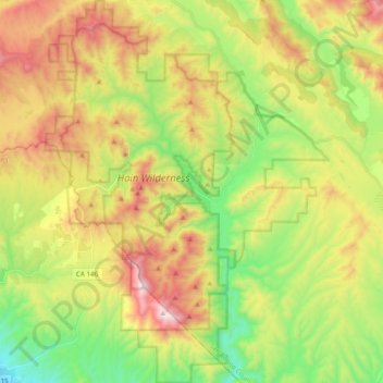
Name: Pinnacles National Park topographic map, elevation, terrain.
Average elevation: 495 m
Minimum elevation: 110 m
Maximum elevation: 1,003 m
Elevation within the boundaries range from 824 to 3,304 feet (251 to 1,007 m) at the peak of North Chalone Peak.
Other topographic maps
Click on a map to view its topography, its elevation and its terrain.
The Fingers
United States > California > San Benito County
The Fingers, San Benito County, California, United States
Average elevation: 575 m
Alta Peak
United States > California > San Benito County
Alta Peak, San Benito County, California, United States
Average elevation: 1,298 m