
Make a donation
Gear up for your next adventure:
As an Amazon Associate, this site earns from qualifying purchases at no extra cost to you.
El Toro Lake topographic map
Click on the map to display elevation.
Make a donation
Gear up for your next adventure:
As an Amazon Associate, this site earns from qualifying purchases at no extra cost to you.
About this map
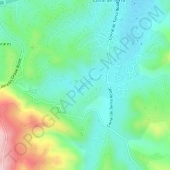
Name: El Toro Lake topographic map, elevation, terrain.
Location: El Toro Lake, Monterey County, California, United States (36.55517 -121.73881 36.55770 -121.73561)
Average elevation: 176 m
Minimum elevation: 94 m
Maximum elevation: 385 m
Make a donation
Gear up for your next adventure:
As an Amazon Associate, this site earns from qualifying purchases at no extra cost to you.
Other topographic maps
Click on a map to view its topography, its elevation and its terrain.
Marina
United States > California > Monterey County > Marina
Marina is a city in Monterey County, California, United States. The United States Census Bureau estimated its 2019 population at 22,781. Marina is located along the central coast of California, 8 miles (13 km) west of Salinas, and 8 miles (13 km) north of Monterey. Marina is on California State Route 1 between…
Average elevation: 17 m
Make a donation
Gear up for your next adventure:
As an Amazon Associate, this site earns from qualifying purchases at no extra cost to you.