Geolocate
👉 Easily get elevation data in JSON, GeoTIFF and KML formats using Elevation API
Thank you for supporting this site ❤️
Make a donation

Gear up for your next adventure:

As an Amazon Associate, this site earns from qualifying purchases at no extra cost to you.

Redwood National Park topographic map

Click on the map to display elevation.

Gear up for your next adventure:

As an Amazon Associate, this site earns from qualifying purchases at no extra cost to you.

Redwood National Park

Redwoods prefer sheltered slopes, and they thrive on moist flat ground along rivers below 1,000 feet (300 m) in elevation. Coastal fog provides about 40 percent of their annual water intake. Redwoods have existed along the coast of northern California for at least 20 million years and are related to tree species that existed 160 million years ago in the Jurassic era. About 96 percent of the world's old-growth coast redwood forest has been logged, and almost half (45 percent) of what remains is in the RNSP. The parks protect 38,982 acres (157.75 km2) of old-growth forest, almost equally divided between federal and state management. The International Union for Conservation of Nature named the coast redwood an endangered species in 2011.

Wikipedia (CC-BY-SA 3.0)

👉 Easily get elevation data in JSON, GeoTIFF and KML formats using Elevation API
Thank you for supporting this site ❤️
Make a donation

Gear up for your next adventure:

As an Amazon Associate, this site earns from qualifying purchases at no extra cost to you.

About this map

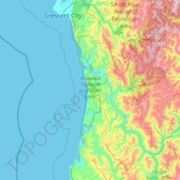
Name: Redwood National Park topographic map, elevation, terrain.

Location: Redwood National Park, Del Norte County, CAL Fire Northern Region, California, United States (41.08143 -124.15978 41.81452 -123.84879)

Average elevation: 367 m

Minimum elevation: -4 m

Maximum elevation: 1,866 m

👉 Easily get elevation data in JSON, GeoTIFF and KML formats using Elevation API
Thank you for supporting this site ❤️
Make a donation

Gear up for your next adventure:

As an Amazon Associate, this site earns from qualifying purchases at no extra cost to you.

Other topographic maps

Click on a map to view its topography, its elevation and its terrain.

Gear up for your next adventure:

🚰Portable Water Filters - Safely drink from Irish streams and mountain lakes
🔒Outdoor Gear Locks - Secure your equipment
🎒Fully Waterproof Rucksacks - Submersible protection for river crossings

As an Amazon Associate, this site earns from qualifying purchases at no extra cost to you.