
Israel topographic map
Interactive map
Click on the map to display elevation.
About this map
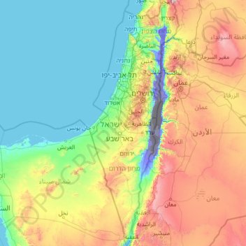
Name: Israel topographic map, elevation, terrain.
Location: Israel (29.45338 34.26750 33.33563 35.89502)
Average elevation: 410 m
Minimum elevation: -415 m
Maximum elevation: 2,320 m
At the other extreme, mountainous regions can be windy and cold, and areas at elevation of 750 metres (2,460 ft) or more (same elevation as Jerusalem) will usually receive at least one snowfall each year. From May to September, rain in Israel is rare. With scarce water resources, Israel has developed various water-saving technologies, including drip irrigation. Israelis also take advantage of the considerable sunlight available for solar energy, making Israel the leading nation in solar energy use per capita—practically every house uses solar panels for water heating.
Other topographic maps
Click on a map to view its topography, its elevation and its terrain.
Ireland
Ireland
Average elevation: 44 m
Chasiv Yar
Chasiv Yar, Chasiv Yar urban hromada, Bakhmut Raion, Donetsk Oblast, 84551-84556, Ukraine
Average elevation: 213 m
Croatia
Croatia
Average elevation: 323 m
Leckaun
Leckaun, Drumkeeran ED, Manorhamilton Municipal District, County Leitrim, Connacht, Ireland
Average elevation: 220 m
Latvia
Latvia
Average elevation: 72 m
Cork
Ireland > County Cork > Cork
Cork, County Cork, Munster, T12 T997, Ireland
Average elevation: 94 m
Crowborough
United Kingdom > England > East Sussex > Wealden
Crowborough, Wealden, East Sussex, England, United Kingdom
Average elevation: 146 m
Pretoria
South Africa > Gauteng > City of Tshwane Metropolitan Municipality
Pretoria, City of Tshwane Metropolitan Municipality, Gauteng, 0126, South Africa
Average elevation: 1,363 m
Utrillas
Spain > Aragon > Cuencas Mineras
Utrillas, Cuencas Mineras, Teruel, Aragon, 44760, Spain
Average elevation: 1,159 m
El Dorado County
El Dorado County, California, United States
Average elevation: 1,286 m
Baghdad
Baghdad, Green Zone Municipality, Baghdad Governorate, Iraq
Average elevation: 36 m
Nacogdoches County
Nacogdoches County, Texas, United States
Average elevation: 93 m
Madagascar
Madagascar
Average elevation: 139 m
Czechia
Czechia
Average elevation: 369 m
Makhuduthamaga Local Municipality
South Africa > Limpopo > Sekhukhune District Municipality
Makhuduthamaga Local Municipality, Sekhukhune District Municipality, Limpopo, South Africa
Average elevation: 1,140 m
Cabernardi
Italy > Marche > Ancona > Sassoferrato
Cabernardi, Sassoferrato, Ancona, Marche, Italy
Average elevation: 381 m
La Zoma
Spain > Aragon > Cuencas Mineras
La Zoma, Cuencas Mineras, Teruel, Aragon, Spain
Average elevation: 1,256 m
Villarluengo
Spain > Aragon > Maestrazgo
Villarluengo, Maestrazgo, Teruel, Aragon, Spain
Average elevation: 1,265 m
Forcall
Forcall, els Ports, Castelló / Castellón, Valencian Community, 12310, Spain
Average elevation: 854 m
Itchen Abbas
United Kingdom > England > Hampshire > Winchester
Itchen Abbas, Winchester, Hampshire, England, SO21 1DJ, United Kingdom
Average elevation: 81 m
Ballinacor East
Ballinacor East, Dunganstown South ED, The Municipal District of Arklow, County Wicklow, Leinster, Ireland
Average elevation: 65 m
Bangladesh
Bangladesh
Average elevation: 161 m
Monterey County
Monterey County, California, United States
Average elevation: 282 m
Europe
Europe
Average elevation: 223 m
Mada'in
Mada'in, Tell Al-Daman Subdistrict, Mount Simeon District, Aleppo Governorate, Syria
Average elevation: 402 m
Wyong
Wyong, Central Coast Council, New South Wales, 2259, Australia
Average elevation: 9 m
Rathcormack
Rathcormack, Drumcliff South, Drumcliff West ED, Sligo Municipal Borough District, County Sligo, Connacht, F91 PY24, Ireland
Average elevation: 27 m
Miłomłyn
Poland > Warmian-Masurian Voivodeship > Ostróda County
Miłomłyn, gmina Miłomłyn, Ostróda County, Warmian-Masurian Voivodeship, 14-140, Poland
Average elevation: 109 m
Valencia
Spain > Valencian Community > Comarca de València
Valencia, Comarca de València, Valencia, Valencian Community, Spain
Average elevation: 37 m
Taiwan
Taiwan > Taiwan Province > Xinyi Township
Taiwan, Xinyi Township, Nantou County, Taiwan Province, Taiwan
Average elevation: 196 m
Forster Lookout
Australia > South Australia > Mid Murray Council > Nildottie > Forster
Forster Lookout, Angas Valley Road, Forster, Nildottie, Mid Murray Council, South Australia, 5238, Australia
Average elevation: 39 m
Tres Mojones
Spain > Castile and León > Riocavado de la Sierra
Tres Mojones, Riocavado de la Sierra, Burgos, Castile and León, Spain
Average elevation: 1,753 m
Morella
Morella, els Ports, Castelló / Castellón, Valencian Community, Spain
Average elevation: 949 m
Zoodochos Pigi
Greece > Thessaly and Central Greece > Euboea Regional Unit
Zoodochos Pigi, Mantoudi - Limni - Aghia Anna Municipality, Euboea Regional Unit, Central Greece, Thessaly and Central Greece, 340 04, Greece
Average elevation: 80 m
Nayaro
Indonesia > Central Papua > Mimika
Nayaro, Mimika, Central Papua, Western New Guinea, Indonesia
Average elevation: 100 m
St Mullins
St Mullins, The Municipal District of Muinebeag, The Municipal District of New Ross, County Carlow, Leinster, Ireland
Average elevation: 138 m
Kageshwori Manohara
Nepal > Bagmati Province > Kathmandu
Kageshwori Manohara, Kageshwori Manohara Municipality, Kathmandu, Bagmati Province, 46603, Nepal
Average elevation: 1,386 m
Sominot
Philippines > Zamboanga del Sur
Sominot, Zamboanga del Sur, Zamboanga Peninsula, 7022, Philippines
Average elevation: 261 m
Ardfinnan
Ardfinnan, The Municipal District of Cahir — Cashel, County Tipperary, Munster, E91 A7D8, Ireland
Average elevation: 51 m