
Thank you for supporting this site ❤️
Make a donation
Make a donation
Gear up for your next adventure:
As an Amazon Associate, this site earns from qualifying purchases at no extra cost to you.
Utrillas topographic map
Click on the map to display elevation.
Thank you for supporting this site ❤️
Make a donation
Make a donation
Gear up for your next adventure:
As an Amazon Associate, this site earns from qualifying purchases at no extra cost to you.
About this map
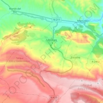
Name: Utrillas topographic map, elevation, terrain.
Location: Utrillas, Cuencas Mineras, Teruel, Aragon, 44760, Spain (40.77190 -0.96114 40.82848 -0.81595)
Average elevation: 1,159 m
Minimum elevation: 806 m
Maximum elevation: 1,543 m
Thank you for supporting this site ❤️
Make a donation
Make a donation
Gear up for your next adventure:
As an Amazon Associate, this site earns from qualifying purchases at no extra cost to you.