
Malaysia topographic map
Interactive map
Click on the map to display elevation.
About this map
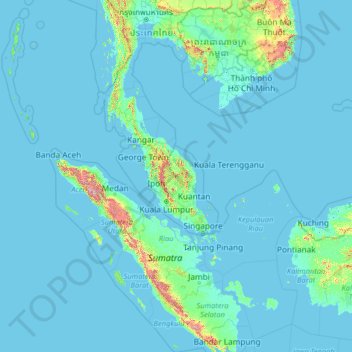
Name: Malaysia topographic map, elevation, terrain.
Location: Malaysia (0.85382 98.73651 8.38015 119.46996)
Average elevation: 54 m
Minimum elevation: -3 m
Maximum elevation: 3,191 m
The two parts of Malaysia, separated from each other by the South China Sea, share a largely similar landscape in that both Peninsular and East Malaysia feature coastal plains rising to hills and mountains. Peninsular Malaysia, containing 40 per cent of Malaysia's land area, extends 740 km (460 mi) from north to south, and its maximum width is 322 km (200 mi). It is divided between its east and west coasts by the Titiwangsa Mountains, rising to a peak elevation of 2,183 metres (7,162 ft) at Mount Korbu, part of a series of mountain ranges running down the centre of the peninsula. These mountains are heavily forested, and mainly composed of granite and other igneous rocks. Much of it has been eroded, creating a karst landscape. The range is the origin of some of Peninsular Malaysia's river systems. The coastal plains surrounding the peninsula reach a maximum width of 50 kilometres (31 mi), and the peninsula's coastline is nearly 1,931 km (1,200 mi) long, although harbours are only available on the western side.
Other topographic maps
Click on a map to view its topography, its elevation and its terrain.
Ireland
Ireland
Average elevation: 44 m
Chasiv Yar
Chasiv Yar, Chasiv Yar urban hromada, Bakhmut Raion, Donetsk Oblast, 84551-84556, Ukraine
Average elevation: 213 m
Cork
Ireland > County Cork > Cork
Cork, County Cork, Munster, T12 T997, Ireland
Average elevation: 94 m
Croatia
Croatia
Average elevation: 323 m
Czechia
Czechia
Average elevation: 369 m
Latvia
Latvia
Average elevation: 72 m
Bangladesh
Bangladesh
Average elevation: 161 m
Itchen Abbas
United Kingdom > England > Hampshire > Winchester
Itchen Abbas, Winchester, Hampshire, England, SO21 1DJ, United Kingdom
Average elevation: 81 m
Monterey County
Monterey County, California, United States
Average elevation: 282 m
Rathcormack
Rathcormack, Drumcliff South, Drumcliff West ED, Sligo Municipal Borough District, County Sligo, Connacht, F91 PY24, Ireland
Average elevation: 27 m
Utrillas
Spain > Aragon > Cuencas Mineras
Utrillas, Cuencas Mineras, Teruel, Aragon, 44760, Spain
Average elevation: 1,159 m
La Zoma
Spain > Aragon > Cuencas Mineras
La Zoma, Cuencas Mineras, Teruel, Aragon, Spain
Average elevation: 1,256 m
Villarluengo
Spain > Aragon > Maestrazgo
Villarluengo, Maestrazgo, Teruel, Aragon, Spain
Average elevation: 1,265 m
Forcall
Forcall, els Ports, Castelló / Castellón, Valencian Community, 12310, Spain
Average elevation: 854 m
Baghdad
Baghdad, Green Zone Municipality, Baghdad Governorate, Iraq
Average elevation: 36 m
Nacogdoches County
Nacogdoches County, Texas, United States
Average elevation: 93 m
Taiwan
Taiwan > Taiwan Province > Xinyi Township
Taiwan, Xinyi Township, Nantou County, Taiwan Province, Taiwan
Average elevation: 196 m
El Dorado County
El Dorado County, California, United States
Average elevation: 1,286 m
Valencia
Spain > Valencian Community > Comarca de València
Valencia, Comarca de València, Valencia, Valencian Community, Spain
Average elevation: 37 m
Woodford Halse
United Kingdom > England > West Northamptonshire
Woodford Halse, West Northamptonshire, England, NN11 3NS, United Kingdom
Average elevation: 154 m
Forster Lookout
Australia > South Australia > Mid Murray Council > Nildottie > Forster
Forster Lookout, Angas Valley Road, Forster, Nildottie, Mid Murray Council, South Australia, 5238, Australia
Average elevation: 39 m
Tres Mojones
Spain > Castile and León > Riocavado de la Sierra
Tres Mojones, Riocavado de la Sierra, Burgos, Castile and León, Spain
Average elevation: 1,753 m
Morella
Morella, els Ports, Castelló / Castellón, Valencian Community, Spain
Average elevation: 949 m
Ballinacor East
Ballinacor East, Dunganstown South ED, The Municipal District of Arklow, County Wicklow, Leinster, Ireland
Average elevation: 65 m
Europe
Europe
Average elevation: 223 m
Storumans kommun
Storumans kommun, Västerbotten County, Sweden
Average elevation: 588 m
San Sebastián
Spain > Autonomous Community of the Basque Country
San Sebastián, Gipuzkoa, Autonomous Community of the Basque Country, Spain
Average elevation: 120 m
Mada'in
Mada'in, Tell Al-Daman Subdistrict, Mount Simeon District, Aleppo Governorate, Syria
Average elevation: 402 m
El Salvador
El Salvador
Average elevation: 484 m
St Mullins
St Mullins, The Municipal District of Muinebeag, The Municipal District of New Ross, County Carlow, Leinster, Ireland
Average elevation: 138 m
Kageshwori Manohara
Nepal > Bagmati Province > Kathmandu
Kageshwori Manohara, Kageshwori Manohara Municipality, Kathmandu, Bagmati Province, 46603, Nepal
Average elevation: 1,386 m
Ardfinnan
Ardfinnan, The Municipal District of Cahir — Cashel, County Tipperary, Munster, E91 A7D8, Ireland
Average elevation: 51 m
Tooele County
United States of America > Utah
Tooele County, Utah, United States of America
Average elevation: 1,462 m
Victorville
United States > California > San Bernardino County
Victorville, San Bernardino County, California, United States
Average elevation: 920 m
Wyong
Wyong, Central Coast Council, New South Wales, 2259, Australia
Average elevation: 9 m
Toliara
Toliara, Atsimo-Andrefana, Province de Toliara, 601, Madagascar
Average elevation: 38 m
Madagascar
Madagascar
Average elevation: 139 m
Zoodochos Pigi
Greece > Thessaly and Central Greece > Euboea Regional Unit
Zoodochos Pigi, Mantoudi - Limni - Aghia Anna Municipality, Euboea Regional Unit, Central Greece, Thessaly and Central Greece, 340 04, Greece
Average elevation: 80 m
Nayaro
Indonesia > Central Papua > Mimika
Nayaro, Mimika, Central Papua, Western New Guinea, Indonesia
Average elevation: 100 m