
Pyrenees topographic map
Click on the map to display elevation.
Pyrenees
The Pyrenees are a mountain range straddling the border of France and Spain. They extend nearly 500 km (310 mi) from their union with the Cantabrian Mountains to Cap de Creus on the Mediterranean coast, reaching a maximum altitude of 3,404 metres (11,168 ft) at the peak of Aneto.
About this map
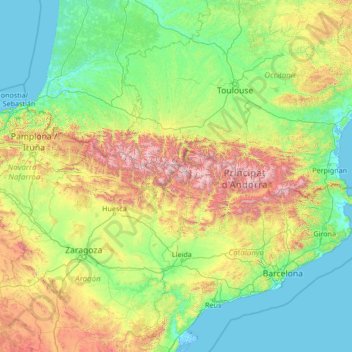
Name: Pyrenees topographic map, elevation, terrain.
Location: Pyrenees, Spain (41.72777 -2.07642 43.39906 3.32224)
Average elevation: 491 m
Minimum elevation: -4 m
Maximum elevation: 3,311 m
Other topographic maps
Click on a map to view its topography, its elevation and its terrain.
Torrevieja
Spain > Valencian Community > el Baix Segura / La Vega Baja del Segura
Average elevation: 7 m
Canary Islands
The Canary Islands, especially Tenerife, Gran Canaria, Fuerteventura, and Lanzarote, are a major tourist destination, with over 16 million visitors in 2023. This is due to their beaches, subtropical climate, and important natural attractions, especially Maspalomas in Gran Canaria and Mount Teide, a World…
Average elevation: 13 m
Córdoba
The differences in elevation in the Valley are very small, ranging from 100 and 170 metres above sea level, with the city proper located at an average altitude of roughly 125 metres above sea level. The landscape of the valley is further subdivided in the piedmont connecting with the Sierra, the fluvial…
Average elevation: 281 m
Mijas
Spain > Andalusia > Costa del Sol Occidental
The climate changes gradually with increasing elevation in the mountains. Temperatures can drop to 10 °C (50 °F). In the peaks, over 600 m (2,000 ft) high, some ice may form in winter, while precipitation increases to almost 800 mm (32 in).
Average elevation: 171 m
Basque Country
The Basque Country region is dominated by a warm, humid and wet oceanic climate. The coastal area is part of Green Spain and by extension, the climate is similary for Bayonne and Biarritz as well. Inland areas in Navarre and the southern regions of the autonomous community are transitional, with continental…
Average elevation: 560 m
Zaragoza
On 1 January 2021, the population of the municipality of Zaragoza was 675,301, (as of 2023, the fourth or fifth most populous in Spain) on a land area of 973.78 square kilometres (375.98 square miles). It is the 26th most populous municipality in the European Union. The population of the metropolitan area was…
Average elevation: 361 m
Puerto de la Cruz
Puerto de la Cruz is a city and municipality in the northern part of the island of Tenerife, Canary Islands, Spain. It was formerly known by its English translation, "Port of the Cross", although now it is known by its Spanish name in all languages. Puerto de la Cruz is located on the northern coast, 4 km (2…
Average elevation: 129 m
Morón de la Frontera
In the year 2011 there were 28,489 inhabitants. At that time the municipality was 431.94 km2 (166.77 sq mi), a population density of 65.96 inhabitants/km2, an average altitude of 297 m (974 ft) and is 67 kilometers (42 mi) from the provincial capital, Seville. Morón de la Frontera is ranked 11th in the…
Average elevation: 216 m
Bigastro
Spain > Valencian Community > el Baix Segura / La Vega Baja del Segura
Average elevation: 49 m
Canillas de Aceituno
Spain > Andalusia > La Axarquía
Canillas de Aceituno has an altitude of around 524 meters at the foot of the Sierra de Tejeda and is crowned by the peak of La Maroma at 2,068 meters, the highest in the province. It is a town of narrow streets that are immaculately whitewashed, Moorish arches and corners of flowers.
Average elevation: 677 m
Morella
Morella has an Oceanic climate (Köppen: Cfb) highly influenced by its altitude around 1,000 metres (3,300 ft) and its well inland location, with warm summers and cool winters (cold for Spanish standards) with frequent frosts and snow. Temperatures as low as −10 °C (14 °F) and heavy snowfalls can happen…
Average elevation: 949 m
Puente la Reina/Gares
Spain > Navarre > Izarbeibar-Novenera / Valdizarbe-Novenera
Average elevation: 488 m
Community of Madrid
Most of province lies between 600 and 1,000 m above sea level. However, there the altitude ranges from the 2,428 metres of Peñalara and the 430 metres of the Alberche river when it leaves Villa del Prado into the province of Toledo. Other considerable heights, as well as being famous, are the Bola del Mundo…
Average elevation: 852 m
Navarre
Despite its relatively small size, Navarre features stark contrasts in geography, from the Pyrenees mountain range that dominates the territory to the plains of the Ebro river valley in the south. The highest point in Navarre is Mesa de los Tres Reyes, with an elevation of 2,428 metres (7,965 feet).
Average elevation: 629 m
Isla Nueva
Spain > Valencian Community > el Baix Segura / La Vega Baja del Segura > Benferri
Average elevation: 93 m
Chiclana de la Frontera
Spain > Andalusia > Bay of Cádiz
Chiclana de la Frontera (Spanish pronunciation: [tʃiˈklana ðe la fɾonˈteɾa]) is a town and municipality in southwestern Spain, in the province of Cádiz, Andalucía, near the Gulf of Cádiz. It belongs to the association of municipalities of the Bay of Cádiz (Bahía de Cádiz), the provincial capital of…
Average elevation: 24 m
Alcorcón
The municipality, largely flat, lies at an average altitude of 711 metres above sea level, with the highest point being El Ventorro del Cano (741 m), located in the north of the municipality.
Average elevation: 692 m
Albacete
Albacete is located in the South-East of the Iberian Peninsula, in the plains of La Mancha (part of the Inner Plateau), at an elevation of about 686 metres (2,251 feet).
Average elevation: 786 m