Geolocate

Canary Islands topographic map

Interactive map

Click on the map to display elevation.

Canary Islands

The Canary Islands, especially Tenerife, Gran Canaria, Fuerteventura, and Lanzarote, are a major tourist destination, with over 16 million visitors in 2023. This is due to their beaches, subtropical climate, and important natural attractions, especially Maspalomas in Gran Canaria and Mount Teide, a World Heritage Site in Tenerife. Mount Teide is the highest peak in Spain and the 3rd tallest volcano in the world, measured from its base on the ocean floor. The islands have warm summers and winters warm enough for the climate to be technically tropical at sea level. The amount of precipitation and the level of maritime moderation vary depending on location and elevation. The archipelago includes green areas as well as semi-desert. The islands' high mountains are ideal for astronomical observation, because they lie above the temperature inversion layer. As a result, the archipelago has two professional astronomical observatories: the Teide Observatory on Tenerife, and Roque de los Muchachos Observatory on La Palma.

Wikipedia (CC-BY-SA 3.0)

About this map

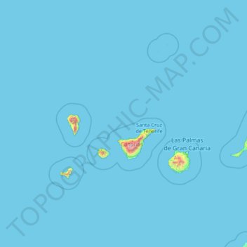
Name: Canary Islands topographic map, elevation, terrain.

Location: Canary Islands, Spain (27.43354 -18.39368 29.91180 -13.10126)

Average elevation: 13 m

Minimum elevation: 0 m

Maximum elevation: 3,432 m

Other topographic maps

Click on a map to view its topography, its elevation and its terrain.

Sedano

Spain > Castile and León > Valle de Sedano

Average elevation: 878 m

Casa Moya

Spain > Rioja > Santo Domingo de la Calzada

Average elevation: 665 m

Sant Joan de Toran

Spain > Catalonia > Val d'Aran > Canejan

Average elevation: 1,496 m

Quintanamanil

Spain > Cantabria > Campoo de Yuso > La Costana

Average elevation: 868 m

Cap Negre

Spain > Valencian Community > Xàbia / Jávea

Average elevation: 40 m

Camarmeña

Spain > Cabrales

Average elevation: 831 m

Cerro de la Muerte

Spain > Andalusia > La Granjuela

Average elevation: 576 m

Pyrenees

Spain

The Pyrenees are a mountain range straddling the border of France and Spain. They extend nearly 500 km (310 mi) from their union with the Cantabrian Mountains to Cap de Creus on the Mediterranean coast, reaching a maximum altitude of 3,404 metres (11,168 ft) at the peak of Aneto.

Average elevation: 491 m

Pedralba

Spain > Valencian Community > La Serranía > Pedralba

Average elevation: 177 m

Jorox

Spain > Andalusia > Sierra de las Nieves > Alozaina

Average elevation: 566 m

Montjuïc

Spain > Catalonia > Barcelonès > Barcelona

Average elevation: 39 m

Maspalomas

Spain > San Bartolomé de Tirajana

Average elevation: 34 m

Monte de El Pardo

Spain > Community of Madrid

Average elevation: 689 m

Costa Brava

Spain

Average elevation: 247 m

Cueto

Spain > Cantabria > Santander

Average elevation: 20 m

La Rimá

Spain > Asturias > Sariego

Average elevation: 411 m

Santiago de la Espada

Spain > Andalusia > Santiago-Pontones

Average elevation: 1,383 m

A Fraguela

Spain > Galicia > Ferrol > Cedeira

Average elevation: 326 m

Mambrillas de Lara

Spain > Castile and León

Average elevation: 1,071 m

Morales

Spain > Castile and León > Berlanga de Duero

Average elevation: 920 m

Doña Marta

Spain > Aragon > Jiloca > Singra

Average elevation: 1,003 m

Roque del Conde

Spain > Adeje

Average elevation: 573 m

Los Cristianos

Spain

Average elevation: 85 m

Morea/Moreda

Spain > Asturias > Aller

Average elevation: 652 m

Salou

Spain > Catalonia > Tarragonès > Salou > Salou

Average elevation: 15 m

Corullón

Spain > Castile and León > El Bierzo > Corullón > Corullón

Average elevation: 630 m

la Falconera

Spain > Catalonia > Mura

Average elevation: 760 m

Los Hoyos

Spain > Canary Islands > Buenavista del Norte

Average elevation: 629 m

León

Spain > Castile and León > León

Average elevation: 838 m

A Coruña

Spain > Galicia > A Coruña

Average elevation: 67 m

Río Negro

Spain > Cantabria > Escalante

Average elevation: 51 m

Linares

Spain > Cantabria > Castro-Urdiales

Average elevation: 416 m

Barrio Aviche

Spain > Cantabria > Santander > Barrio Aviche

Average elevation: 25 m

Buisan

Spain > Aragon > Fanlo > Buisan

Average elevation: 1,378 m

Playa de Ajabo

Spain > Adeje

Average elevation: 35 m

La Gorra

Spain > Navarre > Bardenas Reales de Navarra

Average elevation: 381 m

sa Gorra

Spain > Balearic Islands

Average elevation: 13 m

Cádiz

Spain > Andalusia > Cádiz

The Baluarte de la Candelaria (fortress or stronghold of Candlemas) is a military fortification. Taking advantage of a natural elevation of land, it was constructed in 1672 at the initiative of the governor, Diego Caballero de Illescas. Protected by a seaward-facing wall that had previously served as a…

Average elevation: 3 m

Riaño

Spain > Castile and León > Riaño

Average elevation: 1,140 m

Piedra del Águila

Spain > Andalusia > Beas de Segura

Average elevation: 957 m

Movilla

Spain > Castile and León > Movilla

Average elevation: 668 m

Hazuela de Puntas

Spain > Andalusia > Arenas del Rey

Average elevation: 1,117 m

Guama

Spain > Santiago del Teide

Average elevation: 569 m