Geolocate

Mambrillas de Lara topographic map

Interactive map

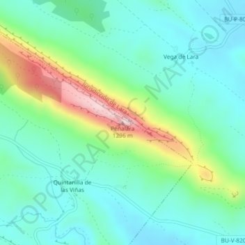
Click on the map to display elevation.

About this map

Name: Mambrillas de Lara topographic map, elevation, terrain.

Location: Mambrillas de Lara, Burgos, Castile and León, 09642, Spain, Peñalara (42.13166 -3.47343 42.13176 -3.47333)

Average elevation: 1,071 m

Minimum elevation: 992 m

Maximum elevation: 1,290 m

Other topographic maps

Click on a map to view its topography, its elevation and its terrain.

Valladolid

Spain > Castile and León

Valladolid is located at roughly 735 metres above sea level, at the centre of the Meseta Norte, the plateau drained by the Duero river basin covering a major part of the Northwest of the Iberian Peninsula. The primitive urban core was built ex novo in the 11th century on a small elevation near the confluence…

Average elevation: 768 m

Aguilar de Campoo

Spain > Castile and León

Average elevation: 999 m

Burgos

Spain > Castile and León

Average elevation: 916 m

Palencia

Spain > Castile and León

Average elevation: 942 m

San Juan del Monte

Spain > Castile and León

Average elevation: 872 m

Zamora

Spain > Castile and León

Average elevation: 803 m

Morales de Toro

Spain > Castile and León

Average elevation: 701 m

Matanza

Spain > Castile and León

Average elevation: 843 m

Arturo Eyries

Spain > Castile and León > Valladolid

Average elevation: 703 m

León

Spain > Castile and León > León

Average elevation: 838 m

Barruecopardo

Spain > Castile and León > Barruecopardo

Average elevation: 667 m

Mudá

Spain > Castile and León > Mudá

Average elevation: 1,051 m

Buenavista

Spain > Castile and León > Buenavista

Average elevation: 936 m

San Justo

Spain > Castile and León > San Justo

Average elevation: 1,332 m

León

Spain > Castile and León

As for the temperatures, in general it is a cold climate due to the altitude and the abundance of frost (which persist from November to May), being more intense in the mountainous areas reaching -18 °C. Vega de Liordes, an enclave in the León sector of Picos de Europa belonging to the municipality of Posada…

Average elevation: 913 m

Rágama

Spain > Castile and León > Rágama

Average elevation: 845 m