Geolocate

La Rinconada topographic map

Click on the map to display elevation.

About this map

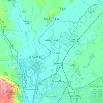
Name: La Rinconada topographic map, elevation, terrain.

Location: La Rinconada, Sevilla, Andalusia, 41309, Spain (37.39542 -6.01019 37.54374 -5.81759)

Average elevation: 23 m

Minimum elevation: 0 m

Maximum elevation: 165 m

Other topographic maps

Click on a map to view its topography, its elevation and its terrain.

Cerro de la Muerte

Spain > Andalusia > La Granjuela

Average elevation: 576 m

Jorox

Spain > Andalusia > Sierra de las Nieves > Alozaina

Average elevation: 566 m

Santiago de la Espada

Spain > Andalusia > Santiago-Pontones

Average elevation: 1,383 m

Gear up for your next adventure:

🥾Lightweight Hiking Shoes - Light, breathable shoes for trail walking
🦯Lightweight Trekking Poles - Reduce knee strain on steep Wicklow or Kerry slopes
🧊Winter Boot Traction - Grip for icy paths in the Mourne or Derryveagh mountains
📊Altimeters & Barometers - Track elevation and weather changes
👣Orthopedic Boot Insoles - Extra comfort for long distance walking

As an Amazon Associate, this site earns from qualifying purchases at no extra cost to you.