
Make a donation
Gear up for your next adventure:
As an Amazon Associate, this site earns from qualifying purchases at no extra cost to you.
Highland topographic map
Click on the map to display elevation.
Make a donation
Gear up for your next adventure:
As an Amazon Associate, this site earns from qualifying purchases at no extra cost to you.
About this map
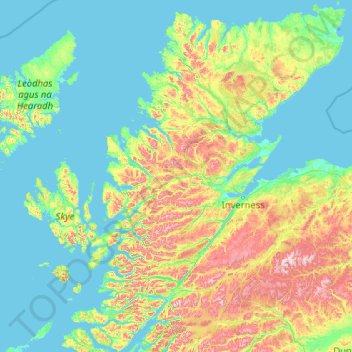
Name: Highland topographic map, elevation, terrain.
Location: Highland, Scotland, United Kingdom (56.49715 -6.78970 58.69752 -3.02396)
Average elevation: 183 m
Minimum elevation: -1 m
Maximum elevation: 1,285 m
Make a donation
Gear up for your next adventure:
As an Amazon Associate, this site earns from qualifying purchases at no extra cost to you.
Other topographic maps
Click on a map to view its topography, its elevation and its terrain.
Tarras Valley Nature Reserve
United Kingdom > Scotland > Dumfries and Galloway
Average elevation: 227 m
Make a donation
Gear up for your next adventure:
As an Amazon Associate, this site earns from qualifying purchases at no extra cost to you.
Make a donation
Gear up for your next adventure:
As an Amazon Associate, this site earns from qualifying purchases at no extra cost to you.
Make a donation
Gear up for your next adventure:
As an Amazon Associate, this site earns from qualifying purchases at no extra cost to you.
Fochabers
United Kingdom > Scotland > Moray
The present village owes its existence to the 4th Duke of Gordon (1743–1827). During the late eighteenth century, during the Scottish Enlightenment, it was fashionable for landowners to found new towns and villages; these can be recognised all over Scotland, because unlike their predecessors they all have…
Average elevation: 59 m
Make a donation
Gear up for your next adventure:
As an Amazon Associate, this site earns from qualifying purchases at no extra cost to you.
Make a donation
Gear up for your next adventure:
As an Amazon Associate, this site earns from qualifying purchases at no extra cost to you.
Ballater
United Kingdom > Scotland > Aberdeenshire
Ballater (/ˈbælətər/, Scottish Gaelic: Bealadair) is a village in Aberdeenshire, Scotland, on the River Dee, immediately east of the Cairngorm Mountains. Situated at an elevation of 213 metres (699 feet), Ballater is a centre for hikers and known for its spring water, once said to cure scrofula. It is home…
Average elevation: 360 m
Make a donation
Gear up for your next adventure:
As an Amazon Associate, this site earns from qualifying purchases at no extra cost to you.
Make a donation
Gear up for your next adventure:
As an Amazon Associate, this site earns from qualifying purchases at no extra cost to you.
Make a donation
Gear up for your next adventure:
As an Amazon Associate, this site earns from qualifying purchases at no extra cost to you.
Make a donation
Gear up for your next adventure:
As an Amazon Associate, this site earns from qualifying purchases at no extra cost to you.
Eskdalemuir
United Kingdom > Scotland > Dumfries and Galloway
In spite of it being located inland, the dull and wet nature of the climate due to the elevation leads to chilly summers that are colder than more northerly locations such as Glasgow and Edinburgh. The inland nature of the climate is more manifest during winter months with frosts being common, and the average…
Average elevation: 246 m
Make a donation
Gear up for your next adventure:
As an Amazon Associate, this site earns from qualifying purchases at no extra cost to you.
Make a donation
Gear up for your next adventure:
As an Amazon Associate, this site earns from qualifying purchases at no extra cost to you.
Aonach Beag
United Kingdom > Scotland > Highland
Aonach Beag is linked to its close neighbour to the north, Aonach Mòr, by a high saddle or bealach. The name Aonach Beag (small ridge) might imply that this mountain is smaller than Aonach Mòr (big ridge). However, Aonach Beag is higher; the names refer to the relative bulk of the two mountains rather than…
Average elevation: 825 m
Make a donation
Gear up for your next adventure:
As an Amazon Associate, this site earns from qualifying purchases at no extra cost to you.
Port Logan
United Kingdom > Scotland > Dumfries and Galloway
On 27 July 1944, two Douglas C-47 Skytrains (one was serial number 42-93038) of the United States Army Air Forces were on a flight from Filton to a stop at Prestwick before flying on to the United States. The flight was transporting wounded soldiers. The flight encountered bad weather, and the pilot of…
Average elevation: 30 m
Make a donation
Gear up for your next adventure:
As an Amazon Associate, this site earns from qualifying purchases at no extra cost to you.
Easthaugh of Ballyoukan
United Kingdom > Scotland > Perth and Kinross > Pitlochry
Average elevation: 199 m
Glen Coe
United Kingdom > Scotland > Highland > Glencoe
Habitats within Glen Coe include birch woodland, moorland and peatbogs. The upland parts of the glen are one of the best habitats for alpine and sub-alpine plants in Lochaber, due to the underlying geology and range of altitude. Typical plants found on the highest slopes of the glen include lady's…
Average elevation: 414 m
Make a donation
Gear up for your next adventure:
As an Amazon Associate, this site earns from qualifying purchases at no extra cost to you.
Ben More Assynt
United Kingdom > Scotland > Highland
In 2012, the Commonwealth War Graves Commission decided to replace the existing cairn, which had deteriorated in the harsh climate, with a 600-kilogramme granite marker to identify and protect the burial site. At an elevation of around 600 m (2,000 ft), the burial site on Ben More Assynt is one of the…
Average elevation: 679 m
Make a donation
Gear up for your next adventure:
As an Amazon Associate, this site earns from qualifying purchases at no extra cost to you.
Abbey St. Bathans
United Kingdom > Scotland > Scottish Borders
Abbey St Bathans (Scottish Gaelic: Abaid Bhaoithin) is a parish in the Lammermuir district of Berwickshire, in the eastern part of the Scottish Borders. Unique in its topography, it is situated in a long winding steep wooded valley that follows the Whiteadder Water. The parish had a population of 106 at the…
Average elevation: 212 m
Make a donation
Gear up for your next adventure:
As an Amazon Associate, this site earns from qualifying purchases at no extra cost to you.
Make a donation
Gear up for your next adventure:
As an Amazon Associate, this site earns from qualifying purchases at no extra cost to you.
Make a donation
Gear up for your next adventure:
As an Amazon Associate, this site earns from qualifying purchases at no extra cost to you.
Make a donation
Gear up for your next adventure:
As an Amazon Associate, this site earns from qualifying purchases at no extra cost to you.
Make a donation
Gear up for your next adventure:
As an Amazon Associate, this site earns from qualifying purchases at no extra cost to you.
Make a donation
Gear up for your next adventure:
As an Amazon Associate, this site earns from qualifying purchases at no extra cost to you.
Make a donation
Gear up for your next adventure:
As an Amazon Associate, this site earns from qualifying purchases at no extra cost to you.
Make a donation
Gear up for your next adventure:
As an Amazon Associate, this site earns from qualifying purchases at no extra cost to you.
Make a donation
Gear up for your next adventure:
As an Amazon Associate, this site earns from qualifying purchases at no extra cost to you.