
Ballachulish topographic map
Interactive map
Click on the map to display elevation.
About this map
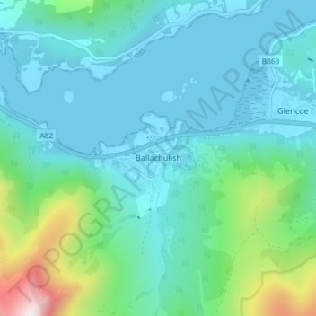
Name: Ballachulish topographic map, elevation, terrain.
Location: Ballachulish, Highland, Scotland, PH49 4JU, United Kingdom (56.65676 -5.15250 56.69676 -5.11250)
Average elevation: 160 m
Minimum elevation: -1 m
Maximum elevation: 912 m
Other topographic maps
Click on a map to view its topography, its elevation and its terrain.
Glen Coe
United Kingdom > Scotland > Highland > Glencoe
Habitats within Glen Coe include birch woodland, moorland and peatbogs. The upland parts of the glen are one of the best habitats for alpine and sub-alpine plants in Lochaber, due to the underlying geology and range of altitude. Typical plants found on the highest slopes of the glen include lady's…
Average elevation: 414 m