
Ben More Assynt topographic map
Interactive map
Click on the map to display elevation.
Ben More Assynt
In 2012, the Commonwealth War Graves Commission decided to replace the existing cairn, which had deteriorated in the harsh climate, with a 600-kilogramme granite marker to identify and protect the burial site. At an elevation of around 600 m (2,000 ft), the burial site on Ben More Assynt is one of the Commission’s most remote grave sites in the UK and the logistics of replacing the cairn have proved challenging. In the end, a Chinook helicopter from RAF Odiham had to be used to carry the granite memorial to the burial site. The granite memorial now marks the spot where Pilot Officer William Drew, Sergeant Jack Emery, Sergeant Harold Arthur Tompsett, Flying Officer James Henry Steyn, Sergeant Charles McPherson Mitchell and Flight Sergeant Thomas Brendon Kenny lost their lives when their aircraft crashed.
About this map
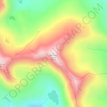
Name: Ben More Assynt topographic map, elevation, terrain.
Location: Ben More Assynt, Highland, Scotland, United Kingdom (58.13792 -4.85857 58.13802 -4.85847)
Average elevation: 679 m
Minimum elevation: 384 m
Maximum elevation: 992 m
Other topographic maps
Click on a map to view its topography, its elevation and its terrain.
Glen Coe
United Kingdom > Scotland > Highland > Glencoe
Habitats within Glen Coe include birch woodland, moorland and peatbogs. The upland parts of the glen are one of the best habitats for alpine and sub-alpine plants in Lochaber, due to the underlying geology and range of altitude. Typical plants found on the highest slopes of the glen include lady's…
Average elevation: 414 m