
Thank you for supporting this site ❤️
Make a donation
Make a donation
Gear up for your next adventure:
As an Amazon Associate, this site earns from qualifying purchases at no extra cost to you.
Maidens topographic map
Click on the map to display elevation.
Thank you for supporting this site ❤️
Make a donation
Make a donation
Gear up for your next adventure:
As an Amazon Associate, this site earns from qualifying purchases at no extra cost to you.
About this map
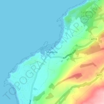
Name: Maidens topographic map, elevation, terrain.
Location: Maidens, South Ayrshire, Scotland, KA26 9NS, United Kingdom (55.31420 -4.83682 55.35420 -4.79682)
Average elevation: 34 m
Minimum elevation: 0 m
Maximum elevation: 164 m
Thank you for supporting this site ❤️
Make a donation
Make a donation
Gear up for your next adventure:
As an Amazon Associate, this site earns from qualifying purchases at no extra cost to you.