
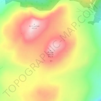
Truagh Mheall topographic map
Interactive map
Click on the map to display elevation.
About this map
Name: Truagh Mheall topographic map, elevation, terrain.
Location: Truagh Mheall, Highland, Scotland, IV47 8TA, United Kingdom (57.21119 -6.33067 57.21129 -6.33057)
Average elevation: 247 m
Minimum elevation: 23 m
Maximum elevation: 431 m
Other topographic maps
Click on a map to view its topography, its elevation and its terrain.
Glen Coe
United Kingdom > Scotland > Highland > Glencoe
Habitats within Glen Coe include birch woodland, moorland and peatbogs. The upland parts of the glen are one of the best habitats for alpine and sub-alpine plants in Lochaber, due to the underlying geology and range of altitude. Typical plants found on the highest slopes of the glen include lady's…
Average elevation: 414 m