
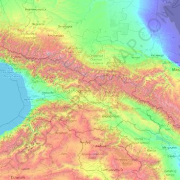
Georgia topographic map
Interactive map
Click on the map to display elevation.
About this map
Name: Georgia topographic map, elevation, terrain.
Location: Georgia (41.05513 39.88448 43.58643 46.73654)
Average elevation: 1,102 m
Minimum elevation: -29 m
Maximum elevation: 5,452 m
The Greater Caucasus Mountain Range forms the northern border of Georgia. The main roads through the mountain range into Russian territory lead through the Roki Tunnel between Shida Kartli and North Ossetia and the Darial Gorge (in the Georgian region of Khevi). The southern portion of the country is bounded by the Lesser Caucasus Mountains. The Greater Caucasus Mountain Range is much higher in elevation than the Lesser Caucasus Mountains, with the highest peaks rising more than 5,000 metres (16,404 ft) above sea level.
Other topographic maps
Click on a map to view its topography, its elevation and its terrain.
Ireland
Ireland
Average elevation: 44 m
Chasiv Yar
Chasiv Yar, Chasiv Yar urban hromada, Bakhmut Raion, Donetsk Oblast, 84551-84556, Ukraine
Average elevation: 213 m
Bangladesh
Bangladesh
Average elevation: 161 m
Latvia
Latvia
Average elevation: 72 m
Cork
Ireland > County Cork > Cork
Cork, County Cork, Munster, T12 T997, Ireland
Average elevation: 94 m
Taiwan
Taiwan > Taiwan Province > Xinyi Township
Taiwan, Xinyi Township, Nantou County, Taiwan Province, Taiwan
Average elevation: 196 m
Croatia
Croatia
Average elevation: 323 m
Pachalik de Benguerir باشوية ابن جرير
Pachalik de Benguerir باشوية ابن جرير, Rhamna Province, Marrakech-Safi, Morocco
Average elevation: 473 m
Monterey County
Monterey County, California, United States
Average elevation: 282 m
Europe
Europe
Average elevation: 223 m
Middlefield
United States > Ohio > Geauga County
Middlefield, Middlefield Township, Geauga County, Ohio, 44062, United States
Average elevation: 351 m
Madagascar
Madagascar
Average elevation: 139 m
Czechia
Czechia
Average elevation: 369 m
Shire of Wellington
Shire of Wellington, Victoria, Australia
Average elevation: 331 m
Tooreen
Tooreen, Claremorris-Swinford Municipal District, County Mayo, Connacht, Ireland
Average elevation: 97 m
Aghamore
Aghamore, Claremorris-Swinford Municipal District, County Mayo, Connacht, Ireland
Average elevation: 111 m
Curraglass
Curraglass, Templemary, The Municipal District of Kanturk-Mallow, County Cork, Munster, Ireland
Average elevation: 135 m
Dallas
United States > Texas > Dallas County
Dallas, Dallas County, Texas, United States
Average elevation: 160 m
Cornwall
United Kingdom > England > Fairy Cross
Cornwall, Broadoak, Fairy Cross, Cornwall, South West England, England, United Kingdom
Average elevation: 49 m
Tooele County
United States of America > Utah
Tooele County, Utah, United States of America
Average elevation: 1,462 m
San Bernardino County
San Bernardino County, California, United States
Average elevation: 763 m
Cerro Gordo County
Cerro Gordo County, Iowa, United States
Average elevation: 358 m
Clearwater
United States > Florida > Pinellas County
Clearwater, Pinellas County, Florida, United States
Average elevation: 8 m
High Peak
United Kingdom > England > Derbyshire
High Peak, Derbyshire, England, United Kingdom
Average elevation: 303 m
Baga-uma
Philippines > Masbate > Aroroy
Baga-uma, Aroroy, Masbate, Bicol Region, Philippines
Average elevation: 13 m
Fraijanes
Guatemala > Guatemala Department
Fraijanes, Guatemala Department, 01052, Guatemala
Average elevation: 1,493 m
Thoiry
France > Auvergne-Rhône-Alpes > Ain
Thoiry, Gex, Ain, Auvergne-Rhône-Alpes, Metropolitan France, 01710, France
Average elevation: 713 m
Woodford Halse
United Kingdom > England > West Northamptonshire
Woodford Halse, West Northamptonshire, England, NN11 3NS, United Kingdom
Average elevation: 154 m
Moldova
Moldova
Average elevation: 171 m
Rathcormack
Rathcormack, Drumcliff South, Drumcliff West ED, Sligo Municipal Borough District, County Sligo, Connacht, F91 PY24, Ireland
Average elevation: 27 m