
Duhok topographic map
Interactive map
Click on the map to display elevation.
About this map
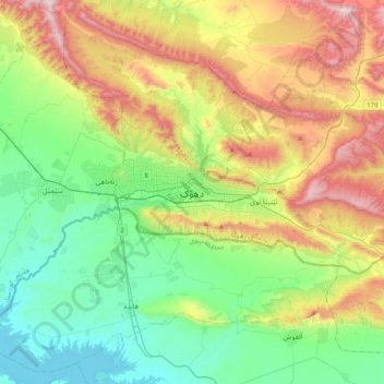
Name: Duhok topographic map, elevation, terrain.
Average elevation: 681 m
Minimum elevation: 304 m
Maximum elevation: 1,420 m
Other topographic maps
Click on a map to view its topography, its elevation and its terrain.
Babylon
Iraq > Babil Governorate > Qaryat Annan
A topographical survey at the site was conducted in 1974, followed in 1977 by a review of the stratigraphical position of the main monuments and reconsideration of ancient water levels, by the Turin Centre for Archaeological Research and Excavations in the Middle East and Asia, and the Iraqi-Italian Institute…
Average elevation: 32 m