
Europe topographic map
Interactive map
Click on the map to display elevation.
Europe
Europe's topography is characterized by a striking contrast between its rugged southern mountains and the expansive plains of the north. The continent is often described as a "peninsula of peninsulas," featuring major peninsulas like the Iberian, Italian, and Balkan, each with unique geological features. In the southern regions, mountain ranges such as the Alps and the Pyrenees rise dramatically, with elevations frequently exceeding 9,800 feet (3,000 meters). Moving northward, the terrain gradually descends into the Great European Plain, a vast lowland stretching from the Pyrenees in the west to the Ural Mountains in the east, where most elevations are below 1,640 feet (500 meters). This plain is interspersed with rolling hills and valleys, making it one of the most agriculturally productive areas in Europe, while also being historically significant due to its accessibility for trade and invasion. The northern regions, including Scandinavia and the British Isles, are marked by fjords and rugged uplands, contributing to a diverse and complex landscape across the continent.
About this map
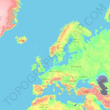
Name: Europe topographic map, elevation, terrain.
Location: Europe (26.00000 -15.00000 76.00000 35.00000)
Average elevation: 223 m
Minimum elevation: -30 m
Maximum elevation: 3,987 m
Other topographic maps
Click on a map to view its topography, its elevation and its terrain.
Ireland
Ireland's topography is characterized by a central limestone plain, averaging about 75 meters (246 feet) above sea level, interspersed with numerous lakes, bogs, and low ridges. This plain is encircled by coastal mountains of varying geological compositions. In the southwest, the MacGillycuddy's Reeks,…
Average elevation: 44 m
Bangladesh
Bangladesh is predominantly rich fertile flat land. Most of it is less than 12 m (39 ft) above sea level, and it is estimated that about 10% of its land would be flooded if the sea level were to rise by 1 m (3.3 ft). 17% of the country is covered by forests and 12% is covered by hill systems. The country's…
Average elevation: 161 m
Croatia
The territory covers 56,594 square kilometres (21,851 square miles), consisting of 56,414 square kilometres (21,782 square miles) of land and 128 square kilometres (49 square miles) of water. It is the world's 127th largest country. Elevation ranges from the mountains of the Dinaric Alps with the highest point…
Average elevation: 323 m
Virginia
Forests cover 62% of Virginia as of 2021, of which 80% is considered hardwood forest, meaning that trees in Virginia are primarily deciduous and broad-leaved. The other 20% is pine, with loblolly and shortleaf pine dominating much of central and eastern Virginia. In the western and mountainous parts of the…
Average elevation: 248 m
Vancouver Island
The rain shadow effect of the island's mountains, as well as the mountains of Washington's Olympic Peninsula, creates wide variation in precipitation. The west coast is considerably wetter than the east coast. Average annual precipitation ranges from 6,650 mm (262 in) at Hucuktlis Lake on the west coast…
Average elevation: 411 m
Latvia
Coastal regions, especially the western coast of the Courland Peninsula, possess a more maritime climate with cooler summers and milder winters, while eastern parts exhibit a more continental climate with warmer summers and harsher winters. Nevertheless, the temperature variations are little as the territory…
Average elevation: 72 m
Seattle
United States > Washington > King County
The city is hilly in some places. Like Rome, the city is said to lie on seven hills; the lists vary but typically include Capitol Hill, First Hill, West Seattle, Beacon Hill, Queen Anne, Magnolia, and the former Denny Hill. The Wallingford, Delridge, Mount Baker, Seward Park, Washington Park, Broadmoor,…
Average elevation: 40 m
Madrid
Madrid lies in the centre of the Iberian peninsula on the southern Meseta Central, 60 km south of the Guadarrama mountain range and straddling the Jarama and Manzanares river sub-drainage basins, in the wider Tagus River catchment area. With an average altitude of 650 metres (2,130 ft), Madrid is the second…
Average elevation: 671 m
East Riding of Yorkshire
The western part of the district in the Vale of York borders on and is drained by the River Derwent. The landscape is generally low-lying and flat although minor ridges and glacial moraines provide some variations in topography. Where there are dry sandy soils there are remnants of historic heathlands and…
Average elevation: 30 m
Valencia
Spain > Valencian Community > Comarca de València
The maximum of precipitation occurs in the Autumn, coinciding with the time of the year when cold drop (gota fría) episodes of heavy rainfall—associated to cut-off low pressure systems at high altitude— are common along the Western mediterranean coast. The year-on-year variability in precipitation may be,…
Average elevation: 37 m
Czechia
Temperatures vary depending on the elevation. In general, at higher altitudes, the temperatures decrease and precipitation increases. The wettest area in the Czech Republic is found around Bílý Potok in Jizera Mountains and the driest region is the Louny District to the northwest of Prague. Another factor is…
Average elevation: 369 m
Geneva
The altitude of Geneva is 373.6 m (1,225.7 ft) and corresponds to the altitude of the largest of the Pierres du Niton, two large rocks emerging from the lake which date from the last ice age. This rock was chosen by General Guillaume Henri Dufour as the reference point for surveying in Switzerland. The second…
Average elevation: 404 m
Cork
The climate of Cork, like the majority of Ireland, is mild oceanic (Cfb in the Köppen climate classification) and changeable with abundant rainfall and a lack of temperature extremes. Cork lies in plant Hardiness zone 9b. Met Éireann maintains a climatological weather station at Cork Airport, a few…
Average elevation: 79 m
Madagascar
Along the length of the eastern coast runs a narrow and steep escarpment containing much of the island's remaining tropical lowland forest. To the west of this ridge lies a plateau in the center of the island ranging in altitude from 750 to 1,500 m (2,460 to 4,920 ft) above sea level. These central highlands,…
Average elevation: 139 m
El Salvador
El Salvador has a tropical climate with pronounced wet and dry seasons. Temperatures vary primarily with elevation and show little seasonal change. The Pacific lowlands are uniformly hot; the central plateau and mountain areas are more moderate. The rainy season extends from May to October; this time of year…
Average elevation: 484 m
County Kerry
Bounded by the Atlantic Ocean, Kerry is Ireland's most westerly county. Its rugged coastline stretches for 886 kilometres (551 miles) and is characterised by bays, sea cliffs, beaches and many small offshore islands, of which the Blaskets and the Skelligs are the most notable. The county's peninsulas have a…
Average elevation: 123 m
County Wicklow
The county experiences a narrow annual temperature range. Typical daytime highs range from 17–22 °C (63–72 °F) throughout the county in July and August, with overnight lows in the 11–14 °C (52–57 °F) range, although temperatures in the mountains can be 5–10 °C (41–50 °F) lower. Mean January…
Average elevation: 166 m
El Dorado County
El Dorado County (/ˌɛl dəˈrɑːdoʊ/ (listen)), officially the County of El Dorado, is a county located in the U.S. state of California. As of the 2020 census, the population was 191,185. The county seat is Placerville. The county is part of the Sacramento-Roseville-Arden-Arcade, CA Metropolitan…
Average elevation: 1,286 m
Newport Beach
United States > California > Orange County
Newport Beach extends in elevation from sea level to the 1,161 ft (354 m) summit of Signal Peak in the San Joaquin Hills, but the official elevation is 25 ft (7.6 m) above sea level at a location of 33°37′0″N 117°53′51″W / 33.61667°N 117.89750°W / 33.61667; -117.89750 (33.616671, −117.897604).
Average elevation: 14 m
Galicia
The interior of Galicia is characterized by a hilly landscape; mountain ranges rise to 2,000 m (6,600 ft) in the east and south. The coastal areas are mostly an alternate series of rias and beaches. The climate of Galicia is usually temperate and rainy, with markedly drier summers; it is usually classified as…
Average elevation: 456 m
Bhutan
Bhutan is on the southern slopes of the eastern Himalayas, landlocked between the Tibet Autonomous Region of China to the north and the Indian states of Sikkim, West Bengal, Assam to the west and south, and the Indian state of Arunachal Pradesh to the east. It lies between latitudes 26°N and 29°N, and…
Average elevation: 2,736 m
County Donegal
The majority of Donegal has a temperate oceanic climate (Köppen climate classification: Cfb), with upland areas in the Derryveagh and Blue Stack ranges classified as oceanic subpolar (Köppen climate classification: Cfc). The county's climate is heavily influenced by the North Atlantic Current. Due to the…
Average elevation: 73 m
Negros Occidental
Negros Occidental has a tropical climate due to the fact that it is situated close to the equator, being located at least nine degrees north of it. The northern section of the province has a tropical rainforest (Köppen: Af) climate, whereas the southern portion has a tropical monsoon (Köppen: Am) climate.…
Average elevation: 125 m
County Limerick
One possible meaning for the county's name in Irish Luimneach is "the flat area"; this description is accurate as the land consists mostly of a fertile limestone plain. Moreover, the county is ringed by mountains: the Slieve Felims to the northeast, the Galtees to the southeast, the Ballyhoura Mountains to the…
Average elevation: 107 m
India
Average elevation: 1,017 m
Starý Smokovec
Slovakia > Region of Prešov > District of Poprad > Vysoké Tatry
Average elevation: 1,065 m
Portland
United States > Oregon > Multnomah County
Annual snowfall in Portland is 4.3 inches (10.9 cm), which usually falls between December and March. The city of Portland avoids snow more frequently than its suburbs, due in part to its low elevation and the urban heat island effect. Neighborhoods outside of the downtown core, especially in slightly higher…
Average elevation: 77 m
Île de Ré
France > Nouvelle-Aquitaine > Charente-Maritime > Le Bois-Plage-en-Ré
Île de Ré (French pronunciation: [il də ʁe]; variously spelled Rhé or Rhéa; Poitevin: ile de Rét; English: Isle of Ré, /reɪ/ RAY) is an island off the Atlantic coast of France near La Rochelle, Charente-Maritime, on the northern side of the Pertuis d'Antioche strait. Its highest point has an elevation…
Average elevation: 1 m
Wichita
United States > Kansas > Sedgwick County
The city lies on the Arkansas River near the western edge of the Flint Hills in the Wellington-McPherson Lowlands region of the Great Plains. The area's topography is characterized by the broad alluvial plain of the Arkansas River valley and the moderately rolling slopes that rise to the higher lands on either…
Average elevation: 408 m