Cork topographic map
Interactive map
Click on the map to display elevation.
About this map
![Cork topographic map, elevation, terrain](/pub/maps/relation/9ws8/5zr914/thumbnail.jpg)
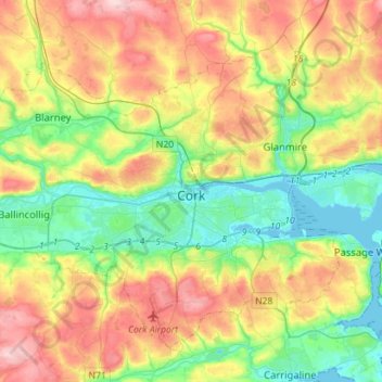
Name: Cork topographic map, elevation, terrain.
Location: Cork, County Cork, Munster, Ireland (51.82731 -8.63785 51.97014 -8.35513)
Average elevation: 79 m
Minimum elevation: -3 m
Maximum elevation: 197 m
The climate of Cork, like the majority of Ireland, is mild oceanic (Cfb in the Köppen climate classification) and changeable with abundant rainfall and a lack of temperature extremes. Cork lies in plant Hardiness zone 9b. Met Éireann maintains a climatological weather station at Cork Airport, a few kilometres south of the city centre. The airport is at an altitude of 151 metres (495 ft) and temperatures can often differ by a few degrees between the airport and the rest of the city. There are also smaller synoptic weather stations at UCC and Clover Hill. Due to its position on the coast, Cork city is subject to occasional flooding.
Other topographic maps
Click on a map to view its topography, its elevation and its terrain.
![Cork topographic map, elevation, terrain](/pub/maps/node/mtdn/897pvn14/icon.jpg)
Cork
Ireland > County Cork > Cork
Cork, County Cork, Munster, T12 T997, Ireland
Average elevation: 94 m
![Castlepook topographic map, elevation, terrain](/pub/maps/way/7hs8/v2ml35m2/icon.jpg)
Castlepook
Castlepook, Ballinree Bridge, Streamhill, The Municipal District of Fermoy, County Cork, Munster, Ireland
Average elevation: 98 m
![Knockeennagroagh topographic map, elevation, terrain](/pub/maps/relation/smt/dhpdtp/icon.jpg)
Knockeennagroagh
Knockeennagroagh, Gortroe, The Municipal District of Fermoy, County Cork, Munster, Ireland
Average elevation: 182 m
![Knockeen topographic map, elevation, terrain](/pub/maps/node/xm57/3lsg3ktp/icon.jpg)
Knockeen
Knockeen, Coulagh ED ED, West Cork, County Cork, Munster, P75 PE80, Ireland
Average elevation: 145 m
![Carriganimmy topographic map, elevation, terrain](/pub/maps/node/w5nx/dc4rp3l/icon.jpg)
Carriganimmy
Carriganimmy, Municipal District of Macroom, County Cork, Munster, P12 DW92, Ireland
Average elevation: 242 m
![Ballineen topographic map, elevation, terrain](/pub/maps/node/w2tf/1djpvrr/icon.jpg)
Ballineen
Ballineen, West Cork, County Cork, Munster, P47 R623, Ireland
Average elevation: 76 m
![Arderrow topographic map, elevation, terrain](/pub/maps/relation/kbkl/m2q751/icon.jpg)
Arderrow
Ireland > County Cork > Cork
Arderrow, Rathcooney, Cork, County Cork, Munster, T23 P270, Ireland
Average elevation: 95 m
![Corbally topographic map, elevation, terrain](/pub/maps/relation/3pz4/wszzkl/icon.jpg)
Corbally
Corbally, Kildinan, The Municipal District of Fermoy, County Cork, Munster, Ireland
Average elevation: 113 m
![Great Island topographic map, elevation, terrain](/pub/maps/relation/6z1h/h38stj/icon.jpg)
Great Island
Great Island, Municipal District of Cobh, County Cork, Munster, Ireland
Average elevation: 20 m
![Maryborough topographic map, elevation, terrain](/pub/maps/relation/3b18/sc2ntp/icon.jpg)
Maryborough
Ireland > County Cork > Cork
Maryborough, Douglas, Cork, County Cork, Munster, Ireland
Average elevation: 51 m
![Drombeg topographic map, elevation, terrain](/pub/maps/relation/v4cz/x12x3l/icon.jpg)
Drombeg
Drombeg, Kilfaughnabeg, West Cork, County Cork, Munster, Ireland
Average elevation: 77 m
![Douglas topographic map, elevation, terrain](/pub/maps/relation/xl57/kv3df3/icon.jpg)
Douglas
Ireland > County Cork > Cork
Douglas, Cork, County Cork, Munster, Ireland
Average elevation: 34 m
![Lismire topographic map, elevation, terrain](/pub/maps/relation/kbt6/cmjpnx/icon.jpg)
Lismire
Lismire, Barleyhill ED, The Municipal District of Kanturk-Mallow, County Cork, Munster, Ireland
Average elevation: 192 m
![Bunlick topographic map, elevation, terrain](/pub/maps/relation/ptmt/9xm5b3/icon.jpg)
Bunlick
Bunlick, Skibbereen Rural, West Cork, County Cork, Munster, Ireland
Average elevation: 32 m
![Lissardagh topographic map, elevation, terrain](/pub/maps/relation/zttj/wtfh3l/icon.jpg)
Lissardagh
Lissardagh, Warrenscourt, Municipal District of Macroom, County Cork, Munster, Ireland
Average elevation: 109 m
![Ardgroom topographic map, elevation, terrain](/pub/maps/node/4gnh/fjfvxtzs/icon.jpg)
Ardgroom
Ardgroom, West Cork, County Cork, Munster, Ireland
Average elevation: 56 m
![Millstreet topographic map, elevation, terrain](/pub/maps/relation/2crr/cjw514/icon.jpg)
Millstreet
Millstreet, Municipal District of Macroom, County Cork, Munster, Ireland
Average elevation: 140 m
![Meelin topographic map, elevation, terrain](/pub/maps/node/x1t6/n7z6r51/icon.jpg)
Meelin
Meelin, The Municipal District of Kanturk-Mallow, County Cork, Munster, Ireland
Average elevation: 246 m
![Shanagarry topographic map, elevation, terrain](/pub/maps/node/jl57/p9rbsdn/icon.jpg)
Shanagarry
Shanagarry, The Municipal District of East Cork, County Cork, Munster, P25 HX82, Ireland
Average elevation: 14 m
![Ardnahinch topographic map, elevation, terrain](/pub/maps/relation/lr1h/jrg457/icon.jpg)
Ardnahinch
Ardnahinch, Ballycottin ED, The Municipal District of East Cork, County Cork, Munster, Ireland
Average elevation: 5 m
![Bandon topographic map, elevation, terrain](/pub/maps/relation/88mt/g92w51/icon.jpg)
Bandon
Bandon, The Municipal District of Bandon-Kinsale, County Cork, Munster, Ireland
Average elevation: 59 m
![Curraglass topographic map, elevation, terrain](/pub/maps/relation/lbnh/xvbx4s/icon.jpg)
Curraglass
Curraglass, Templemary, The Municipal District of Kanturk-Mallow, County Cork, Munster, Ireland
Average elevation: 135 m
![Kilgobbin topographic map, elevation, terrain](/pub/maps/relation/ngrr/l6jzgt/icon.jpg)
Kilgobbin
Kilgobbin, Ballinadee ED, The Municipal District of Bandon-Kinsale, County Cork, Munster, Ireland
Average elevation: 85 m
![Ballincollig topographic map, elevation, terrain](/pub/maps/node/h7gp/rlgdccz/icon.jpg)
Ballincollig
Ireland > County Cork > Cork
Ballincollig, Cork, County Cork, Munster, P31 TW88, Ireland
Average elevation: 62 m
![Inchigeelagh topographic map, elevation, terrain](/pub/maps/relation/2dnx/mw2xrr/icon.jpg)
Inchigeelagh
Inchigeelagh, Municipal District of Macroom, County Cork, Munster, P12 W864, Ireland
Average elevation: 135 m
![Knockawaddra topographic map, elevation, terrain](/pub/maps/relation/hxtp/4d46rr/icon.jpg)
Knockawaddra
Knockawaddra, Ballingurteen ED, West Cork, County Cork, Munster, Ireland
Average elevation: 154 m
![Killeagh topographic map, elevation, terrain](/pub/maps/relation/d8gt/k6fdcz/icon.jpg)
Killeagh
Killeagh, The Municipal District of East Cork, County Cork, Munster, P36 KN61, Ireland
Average elevation: 32 m
![Water-rock topographic map, elevation, terrain](/pub/maps/relation/19m2/xpqj4s/icon.jpg)
Water-rock
Water-rock, Carrigtohill ED, Municipal District of Cobh, County Cork, Munster, Ireland
Average elevation: 22 m
![Coolmore Cross topographic map, elevation, terrain](/pub/maps/node/3vdn/7z42p2t6/icon.jpg)
Coolmore Cross
Coolmore Cross, Carrigaline ED, Municipal District of Carrigaline, County Cork, Munster, P43 DA03, Ireland
Average elevation: 21 m
![Gortroe topographic map, elevation, terrain](/pub/maps/relation/hl51/858km2/icon.jpg)
Gortroe
Gortroe, The Municipal District of Fermoy, County Cork, Munster, P61 TD96, Ireland
Average elevation: 120 m
![Lyre topographic map, elevation, terrain](/pub/maps/relation/fjnh/gtmwtf/icon.jpg)
Lyre
Lyre, Tincoora, The Municipal District of Kanturk-Mallow, County Cork, Munster, Ireland
Average elevation: 214 m
![Dundareirke topographic map, elevation, terrain](/pub/maps/relation/dps8/6w1714/icon.jpg)
Dundareirke
Dundareirke, Kilnamartery, Municipal District of Macroom, County Cork, Munster, Ireland
Average elevation: 116 m
![Castlemartyr topographic map, elevation, terrain](/pub/maps/relation/xrtf/q52rtp/icon.jpg)
Castlemartyr
Castlemartyr, The Municipal District of East Cork, County Cork, Munster, Ireland
Average elevation: 14 m
![Castletownroche topographic map, elevation, terrain](/pub/maps/node/wn18/fz4tk4s/icon.jpg)
Castletownroche
Castletownroche, The Municipal District of Fermoy, County Cork, Munster, P51 K064, Ireland
Average elevation: 67 m
![Ballincollig Regional Park topographic map, elevation, terrain](/pub/maps/way/2kcz/sdhl9tp/icon.jpg)
Ballincollig Regional Park
Ireland > County Cork > Cork
Ballincollig Regional Park, West Village, Carrigrohane Beg ED, Cork, County Cork, Munster, Ireland
Average elevation: 55 m
![Berrings topographic map, elevation, terrain](/pub/maps/relation/gntf/t7gt3q/icon.jpg)
Berrings
Berrings, Dripsey, Municipal District of Macroom, County Cork, Munster, Ireland
Average elevation: 113 m
![Moneyreague topographic map, elevation, terrain](/pub/maps/relation/mgm2/91szb3/icon.jpg)
Moneyreague
Moneyreague, Coolmountain ED, West Cork, County Cork, Munster, Ireland
Average elevation: 122 m
![Ballymore topographic map, elevation, terrain](/pub/maps/relation/hx3q/d96znh/icon.jpg)
Ballymore
Ballymore, Cobh Rural ED, Municipal District of Cobh, County Cork, Munster, Ireland
Average elevation: 40 m
![Macroom topographic map, elevation, terrain](/pub/maps/relation/4p1h/hnrnt6/icon.jpg)
Macroom
Macroom, Municipal District of Macroom, County Cork, Munster, Ireland
Average elevation: 110 m
![Waterfall topographic map, elevation, terrain](/pub/maps/node/sf18/l7xtd5nh/icon.jpg)
Waterfall
Waterfall, Inishkenny, Municipal District of Carrigaline, County Cork, Munster, T12 CYF2, Ireland
Average elevation: 96 m
![Aghabullogue topographic map, elevation, terrain](/pub/maps/node/c157/xndgs5k/icon.jpg)
Aghabullogue
Aghabullogue, Municipal District of Macroom, County Cork, Munster, P12 DY92, Ireland
Average elevation: 133 m
![Liscahane Beg topographic map, elevation, terrain](/pub/maps/relation/k4s/f6dgtp/icon.jpg)
Liscahane Beg
Liscahane Beg, Kinsale Rural, The Municipal District of Bandon-Kinsale, County Cork, Munster, Ireland
Average elevation: 47 m
![Mallow topographic map, elevation, terrain](/pub/maps/relation/8314/jgkqgt/icon.jpg)
Mallow
Mallow, The Municipal District of Kanturk-Mallow, County Cork, Munster, Ireland
Average elevation: 77 m
![Kilmurry topographic map, elevation, terrain](/pub/maps/node/4sm2/k1nf83t6/icon.jpg)
Kilmurry
Kilmurry, Municipal District of Macroom, County Cork, Munster, P14 R940, Ireland
Average elevation: 122 m
![Baltimore topographic map, elevation, terrain](/pub/maps/node/phgt/sjpw518/icon.jpg)
Baltimore
Baltimore, West Cork, County Cork, Munster, P81 F623, Ireland
Average elevation: 23 m
![Glounthaune topographic map, elevation, terrain](/pub/maps/node/flf3/n7q4j51/icon.jpg)
Glounthaune
Glounthaune, Municipal District of Cobh, County Cork, Munster, T45 V201, Ireland
Average elevation: 52 m
![Kilmacsimon topographic map, elevation, terrain](/pub/maps/relation/3r1h/9g1tb3/icon.jpg)
Kilmacsimon
Kilmacsimon, Knockroe, The Municipal District of Bandon-Kinsale, County Cork, Munster, Ireland
Average elevation: 50 m