Geolocate

Vancouver Island topographic map

Interactive map

Click on the map to display elevation.

Vancouver Island

The rain shadow effect of the island's mountains, as well as the mountains of Washington's Olympic Peninsula, creates wide variation in precipitation. The west coast is considerably wetter than the east coast. Average annual precipitation ranges from 6,650 mm (262 in) at Hucuktlis Lake on the west coast (making it the wettest place in North America) to only 608 mm (23.9 in) at Victoria Gonzales, the driest recording station in the provincial capital of Victoria. Precipitation is heaviest in the autumn and winter. Snow is rare at low altitudes, but is common on the island's mountaintops in winter. Skiing is popular at Mount Washington in the mid-island, with an elevation of 1,588 m (5,210 ft).

Wikipedia (CC-BY-SA 3.0)

About this map

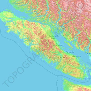
Name: Vancouver Island topographic map, elevation, terrain.

Location: Vancouver Island, British Columbia, Canada (48.30888 -128.43292 50.87683 -123.26476)

Average elevation: 411 m

Minimum elevation: -3 m

Maximum elevation: 3,160 m

Other topographic maps

Click on a map to view its topography, its elevation and its terrain.

Marble Canyon

Canada > British Columbia

Average elevation: 1,221 m

Lake O'Hara

Canada > British Columbia > Columbia-Shuswap Regional District > Area A (Kicking Horse/Kinbasket Lake)

Lake O'Hara is a lake at an elevation of 2,020 metres (6,630 ft) in the alpine area of Yoho National Park, in the province of British Columbia, on the western side of the Great Divide with the province of Alberta and Banff National Park to the east. The lake and the valley are accessible through a bus service…

Average elevation: 2,276 m

Squamish-Lillooet

Canada > British Columbia

Average elevation: 1,545 m

Sunshine Coast

Canada > British Columbia

Average elevation: 649 m

Peace River

Canada > British Columbia

Average elevation: 1,118 m

Central Coast

Canada > British Columbia

Average elevation: 789 m

Northern Rockies

Canada > British Columbia

Average elevation: 512 m