
Iraq topographic map
Interactive map
Click on the map to display elevation.
About this map
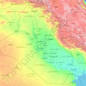
Name: Iraq topographic map, elevation, terrain.
Location: Iraq (29.05857 38.79264 37.38067 49.10677)
Average elevation: 633 m
Minimum elevation: -31 m
Maximum elevation: 3,640 m
The capital, Ninus or Nineveh, was taken by the Medes under Cyaxares, and some 200 years after Xenophon passed over its site, then mere mounds of earth. It remained buried until 1845, when Botta and Layard discovered the ruins of the Assyrian cities. The principal remains are those of Khorsabad, 16 km (10 mi) N.E. of Mosul; of Nimroud, supposed to be the ancient Calah; and of Kouyunjik, in all probability the ancient Nineveh. In these cities are found fragments of several great buildings which seem to have been palace-temples. They were constructed chiefly of sun-dried bricks, and all that remains of them is the lower part of the walls, decorated with sculpture and paintings, portions of the pavements, a few indications of the elevation, and some interesting works connected with the drainage.
Other topographic maps
Click on a map to view its topography, its elevation and its terrain.
Ireland
Ireland
Average elevation: 44 m
Chasiv Yar
Chasiv Yar, Chasiv Yar urban hromada, Bakhmut Raion, Donetsk Oblast, 84551-84556, Ukraine
Average elevation: 213 m
Croatia
Croatia
Average elevation: 323 m
Taiwan
Taiwan > Taiwan Province > Xinyi Township
Taiwan, Xinyi Township, Nantou County, Taiwan Province, Taiwan
Average elevation: 196 m
Bangladesh
Bangladesh
Average elevation: 161 m
Madagascar
Madagascar
Average elevation: 139 m
Cork
Ireland > County Cork > Cork
Cork, County Cork, Munster, T12 T997, Ireland
Average elevation: 94 m
Europe
Europe
Average elevation: 223 m
Latvia
Latvia
Average elevation: 72 m
Tooreen
Tooreen, Claremorris-Swinford Municipal District, County Mayo, Connacht, Ireland
Average elevation: 97 m
Curraglass
Curraglass, Templemary, The Municipal District of Kanturk-Mallow, County Cork, Munster, Ireland
Average elevation: 135 m
Dallas
United States > Texas > Dallas County
Dallas, Dallas County, Texas, United States
Average elevation: 160 m
Cornwall
United Kingdom > England > Fairy Cross
Cornwall, Broadoak, Fairy Cross, Cornwall, South West England, England, United Kingdom
Average elevation: 49 m
Monterey County
Monterey County, California, United States
Average elevation: 282 m
San Bernardino County
San Bernardino County, California, United States
Average elevation: 763 m
Baga-uma
Philippines > Masbate > Aroroy
Baga-uma, Aroroy, Masbate, Bicol Region, Philippines
Average elevation: 13 m
Fraijanes
Guatemala > Guatemala Department
Fraijanes, Guatemala Department, 01052, Guatemala
Average elevation: 1,493 m
Thoiry
France > Auvergne-Rhône-Alpes > Ain
Thoiry, Gex, Ain, Auvergne-Rhône-Alpes, Metropolitan France, 01710, France
Average elevation: 713 m
Nacogdoches County
Nacogdoches County, Texas, United States
Average elevation: 93 m
Miłomłyn
Poland > Warmian-Masurian Voivodeship > Ostróda County
Miłomłyn, gmina Miłomłyn, Ostróda County, Warmian-Masurian Voivodeship, 14-140, Poland
Average elevation: 109 m
Valencia
Spain > Valencian Community > Comarca de València
Valencia, Comarca de València, Valencia, Valencian Community, Spain
Average elevation: 37 m
Czechia
Czechia
Average elevation: 369 m
Aghamore
Aghamore, Claremorris-Swinford Municipal District, County Mayo, Connacht, Ireland
Average elevation: 111 m
Waldenberg
Austria > Bezirk Wels-Land > Gunskirchen
Waldenberg, Gunskirchen, Bezirk Wels-Land, 4623, Austria
Average elevation: 384 m
Waltembourg
Waltembourg, Sarrebourg-Château-Salins, Moselle, Grand Est, Metropolitan France, 57370, France
Average elevation: 322 m
Youngstown
United States > Ohio > Mahoning County
Youngstown, Mahoning County, Ohio, United States
Average elevation: 307 m
Akron
United States > Ohio > Summit County
Akron, Summit County, Ohio, United States
Average elevation: 315 m
Bethesda
United States > North Carolina > Durham County > Durham
Bethesda, Durham, Durham County, North Carolina, 27703, United States
Average elevation: 118 m
McAlpin
United States > West Virginia > Raleigh County
McAlpin, Raleigh County, West Virginia, 25921, United States
Average elevation: 721 m
Portlaoise
Portlaoise, The Municipal District of Portlaoise, County Laois, Leinster, Ireland
Average elevation: 101 m
Lisacul
Lisacul, Roscommon Municipal District, County Roscommon, Connacht, Ireland
Average elevation: 82 m
Leckaun
Leckaun, Drumkeeran ED, Manorhamilton Municipal District, County Leitrim, Connacht, Ireland
Average elevation: 220 m